Country:
 USA
USARegion:
City:
Latitude and Longitude:
Time Zone:
Postal Code:
IP information under different IP Channel
ip-api
Country
Region
City
ASN
Time Zone
ISP
Blacklist
Proxy
Latitude
Longitude
Postal
Route
IPinfo
Country
Region
City
ASN
Time Zone
ISP
Blacklist
Proxy
Latitude
Longitude
Postal
Route
MaxMind
Country
Region
City
ASN
Time Zone
ISP
Blacklist
Proxy
Latitude
Longitude
Postal
Route
Luminati
Country
USASN
Time Zone
America/Chicago
ISP
BWINPARTY-US-01
Latitude
Longitude
Postal
db-ip
Country
Region
City
ASN
Time Zone
ISP
Blacklist
Proxy
Latitude
Longitude
Postal
Route
ipdata
Country
Region
City
ASN
Time Zone
ISP
Blacklist
Proxy
Latitude
Longitude
Postal
Route
Popular places and events near this IP address

Grove Street station (PATH)
Port Authority Trans-Hudson rail station
Distance: Approx. 233 meters
Latitude and longitude: 40.719671,-74.043117
Grove Street station (originally Grove–Henderson Streets) is a station on the PATH system. Located at the intersection of Grove Street, Newark Avenue and Railroad Avenue in the Downtown neighborhood of Jersey City, New Jersey, it is served by the Newark–World Trade Center line at all times, the Journal Square–33rd Street line on weekdays (except for during the late-evening and early-morning hours), and the Journal Square–33rd Street (via Hoboken) line on weekends and during late-evening and early-morning weekday hours.
Van Vorst Township, New Jersey
Distance: Approx. 338 meters
Latitude and longitude: 40.7183,-74.0462
Van Vorst was a township that existed in Hudson County, New Jersey, United States, from 1841 to 1851, that is now a neighborhood in Jersey City. The township was located on the Hudson River, to the west and north of the original territory of Jersey City and across from Manhattan. Van Vorst was incorporated as a township by an Act of the New Jersey Legislature on April 12, 1841, from portions of Bergen Township.
St. Mary High School (Jersey City, New Jersey)
Catholic high school in Hudson County, New Jersey, United States
Distance: Approx. 231 meters
Latitude and longitude: 40.723044,-74.043756
St. Mary High School was a private, Roman Catholic high school in Jersey City, in the U.S. state of New Jersey, that operated as part of the Roman Catholic Archdiocese of Newark until the school was closed in June 2011. As of the 2009-10 school year, the school had an enrollment of 203 students and 12.8 classroom teachers (on an FTE basis), for a student–teacher ratio of 15.9.

Pavonia, New Netherland
European settlement on the Hudson River
Distance: Approx. 354 meters
Latitude and longitude: 40.7237,-74.0424
Pavonia was the first European settlement on the west bank of the North River (Hudson River) that was part of the seventeenth-century province of New Netherland in what would become the present Hudson County, New Jersey.

Great Atlantic and Pacific Tea Company Warehouse
United States historic place
Distance: Approx. 403 meters
Latitude and longitude: 40.72101944,-74.04023333
The Great Atlantic and Pacific Tea Company Warehouse is a historic formerly commercial building at 150 Bay Street in Jersey City, Hudson County, New Jersey, United States. Built as a warehouse for The Great Atlantic & Pacific Tea Company (A&P) in 1900, it is the major surviving remnant of a five-building complex of the nation's first major grocery store chain. It was designated a National Historic Landmark in 1978, and now houses a mix of residences and storage facilities.
Provost Square
Apartment complex in Jersey City, New Jersey, U.S.
Distance: Approx. 406 meters
Latitude and longitude: 40.7204,-74.0403
Provost Square is a partially built apartment complex in Jersey City, New Jersey developed by Toll Brothers. It will consists of two towers, one of which was completed in 2015 and called the Morgan. It is 38 storeys and 102 m (335 ft) tall.

Grace Church Van Vorst
Historic church in New Jersey, United States
Distance: Approx. 174 meters
Latitude and longitude: 40.72272611,-74.04458194
The Grace Church Van Vorst, is located in Jersey City, Hudson County, New Jersey, United States. The church was added to the National Register of Historic Places on August 1, 1979. The church was built in 1853 and was named after the former Van Vorst Township.

Barrow Mansion
Historic house in New Jersey, United States
Distance: Approx. 354 meters
Latitude and longitude: 40.72,-74.04888889
The Dr. William Barrow Mansion is located at 83 Wayne Street between Barrow Street and Jersey Avenue in Downtown Jersey City, Hudson County, New Jersey, United States. The mansion was added to the National Register of Historic Places on May 2, 1977, and is located within the Van Vorst Park Historic District, which itself was dedicated on March 5, 1980, and is roughly bounded by Railroad Avenue, and Henderson, Grand, Bright, and Monmouth Streets.
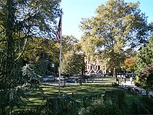
Van Vorst Park
Populated place in Essex County, New Jersey, US
Distance: Approx. 338 meters
Latitude and longitude: 40.7183,-74.0462
Van Vorst Park is a neighborhood in the Historic Downtown of Jersey City, Hudson County, New Jersey, centered on a park sharing the same name. The neighborhood is located west of Paulus Hook and Marin Boulevard, north of Grand Street, east of the Turnpike Extension, and south of The Village and Christopher Columbus Drive. Much of it is included in the Van Vorst Park Historical District.
Jersey City Free Public Library
Public library system in New Jersey, US
Distance: Approx. 323 meters
Latitude and longitude: 40.718948,-74.047406
The Jersey City Free Public Library (JCFPL) is the municipal library system of Jersey City, New Jersey, serving the residents of Hudson County. The library was established in 1889, opened in 1891, and had its first dedicated building, the main library, by 1901. Numerous branches have since opened and as of 2023 there are nine throughout the city as well as a bookmobile.

Jersey City Police Memorial
Bronze sculpture in Jersey City, U.S.
Distance: Approx. 387 meters
Latitude and longitude: 40.71861111,-74.04805556
The Jersey City Police Memorial is a tribute to the fallen officers of Jersey City Police Department located on Montgomery Street near City Hall in Jersey City, New Jersey.
Razza
Restaurant in Jersey City, New Jersey, U.S.
Distance: Approx. 388 meters
Latitude and longitude: 40.717765,-74.044222
Razza is a restaurant in Jersey City, New Jersey. It was included in The New York Times's 2024 list of the 22 best pizzerias in the United States.
Weather in this IP's area
clear sky
21 Celsius
21 Celsius
17 Celsius
22 Celsius
1020 hPa
70 %
1020 hPa
1020 hPa
10000 meters
2.06 m/s
260 degree
05:49:24
20:15:42