Country:
 USA
USARegion:
City:
Latitude and Longitude:
Time Zone:
Postal Code:
IP information under different IP Channel
ip-api
Country
Region
City
ASN
Time Zone
ISP
Blacklist
Proxy
Latitude
Longitude
Postal
Route
IPinfo
Country
Region
City
ASN
Time Zone
ISP
Blacklist
Proxy
Latitude
Longitude
Postal
Route
MaxMind
Country
Region
City
ASN
Time Zone
ISP
Blacklist
Proxy
Latitude
Longitude
Postal
Route
Luminati
Country
USASN
Time Zone
America/Chicago
ISP
CL-1379-14537
Latitude
Longitude
Postal
db-ip
Country
Region
City
ASN
Time Zone
ISP
Blacklist
Proxy
Latitude
Longitude
Postal
Route
ipdata
Country
Region
City
ASN
Time Zone
ISP
Blacklist
Proxy
Latitude
Longitude
Postal
Route
Popular places and events near this IP address
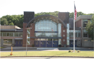
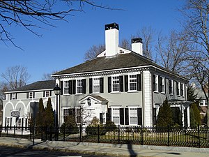
Andover High School (Massachusetts)
Public secondary school in Andover, Massachusetts, United States
Distance: Approx. 1101 meters
Latitude and longitude: 42.6571,-71.1551
Andover High School (formerly Punchard High School, The School at Punchard, or Punchard Free School) is a secondary school in the town of Andover, Massachusetts, United States. It is the only public high school in the Andover Public Schools district. The school's administration is headed by Betty Taylor, the interim principal, and is overseen by Superintendent of Schools Magda Parvey.
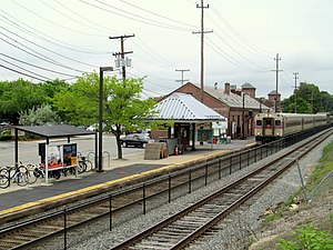
Andover station (MBTA)
Train station in Andover, Massachusetts, US
Distance: Approx. 1742 meters
Latitude and longitude: 42.6579,-71.1446
Andover station is an MBTA Commuter Rail station in Andover, Massachusetts. It serves the Haverhill Line. The station has one platform with a mini-high platform for handicapped accessibility serving one track, while the second track lacks a platform.
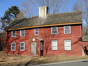
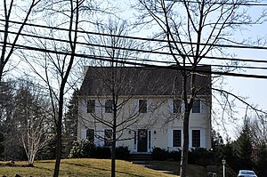
Benjamin Abbot House
Historic house in Massachusetts, United States
Distance: Approx. 727 meters
Latitude and longitude: 42.64638889,-71.15305556
The Benjamin Abbot House or Abbot Homestead is a historic house at 9 Andover Street in Andover, Massachusetts, USA. The house was built in 1711. It was listed on the National Register of Historic Places in 1975.
J. T. Abbot House
Historic house in Massachusetts, United States
Distance: Approx. 1713 meters
Latitude and longitude: 42.65638889,-71.14361111
The J. T. Abbot House is a historic house at 34 Essex Street in Andover, Massachusetts. The Gothic Revival house was built in the late 1840s for Joseph Thompson Abbot by Jacob Chickering, a leading local real estate developer and builder of the mid 19th century. The ornamental detailing is among the most elaborate of the time in the town.

Andover Village Industrial District
Historic district in Massachusetts, United States
Distance: Approx. 1340 meters
Latitude and longitude: 42.65555556,-71.14833333
The Andover Village Industrial District encompasses one of the 19th century industrial mill villages of Andover, Massachusetts known locally as "The Village". The growth of this village contributed to the decision in the 19th century to separate the more rural area of North Andover from the town. It is centered on a stretch of the Shawsheen River between North Main Street on the east and Moraine Street on the west.
Central Street District
United States historic place
Distance: Approx. 1421 meters
Latitude and longitude: 42.65166667,-71.14472222
The Central Street District is a historic district encompassing the traditional heart of Andover, Massachusetts prior to the development in the later 19th century of the current town center. It consists mainly of residential and religious properties along Central Street, from Phillips Street in the south to Essex Street in the north. All of the listed properties have frontage on Central Street, even if their addresses are on one of the adjacent streets.

Chickering House
Historic house in Massachusetts, United States
Distance: Approx. 1757 meters
Latitude and longitude: 42.65611111,-71.14277778
The Chickering House is a historic house at 28 Essex Street in Andover, Massachusetts. It was built by local builder Jacob Chickering as his personal residence sometime in the early 1830s. He only lived in it until 1835, when he moved across the street, giving this house to his parents.
William Foster House
Historic house in Massachusetts, United States
Distance: Approx. 1222 meters
Latitude and longitude: 42.64722222,-71.14666667
The William Foster House is a historic house in Andover, Massachusetts. The core of this house is a three-bay two-story late First Period structure built c. 1720.

West Parish Center District
Historic district in Massachusetts, United States
Distance: Approx. 1037 meters
Latitude and longitude: 42.65722222,-71.16555556
The West Parish Center District encompasses the social and religious center of the part of Andover, Massachusetts, that is located west of the Shawsheen River. It is mostly spread along Lowell Street (Massachusetts Route 133) on either side of a major intersection with four other roads: Shawsheen Road, Reservation Road, Beacon Street, and High Plain Road. The centerpiece of the district is the 1826 West Parish Church, which is the oldest church standing in Andover.
1993 Ramada Hotel drownings
Hotel pool drowning in Andover, MA
Distance: Approx. 1864 meters
Latitude and longitude: 42.648567,-71.184261
On April 7, 1993, three teenage boys died by drowning in a swimming pool at a Ramada Rolling Green Hotel in Andover, Massachusetts. The deaths resulted in a lawsuit against the Ramada and its owners. The drownings came at a time when many area hotels were being constructed without deep ends in their pools, or were renovating their pools to remove them, according to hospitality industry professionals.
Dundee Park
Distance: Approx. 1448 meters
Latitude and longitude: 42.655277,-71.146487
Dundee Park is a suburban business park located in the town of Andover, Massachusetts, situated across from the old Andover train station.
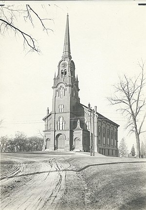
South Church, Andover, Massachusetts
Church in Massachusetts, United States
Distance: Approx. 1601 meters
Latitude and longitude: 42.653325,-71.14313333
The South Church is a Protestant Christian place of worship located in Andover, Massachusetts, US. It was organized as the Second Church of Andover in 1711 with Rev. Samuel Phillips as its first pastor. It is currently part of the United Church of Christ.
Weather in this IP's area
scattered clouds
28 Celsius
28 Celsius
27 Celsius
30 Celsius
1019 hPa
45 %
1019 hPa
1015 hPa
10000 meters
1.54 m/s
40 %
05:31:43
20:10:21