Country:
 Guernsey
Region:
City:
Latitude and Longitude:
Time Zone:
Postal Code:
IP information under different IP Channel
ip-api
Country
Region
City
ASN
Time Zone
ISP
Blacklist
Proxy
Latitude
Longitude
Postal
Route
IPinfo
Country
Region
City
ASN
Time Zone
ISP
Blacklist
Proxy
Latitude
Longitude
Postal
Route
MaxMind
Country
Region
City
ASN
Time Zone
ISP
Blacklist
Proxy
Latitude
Longitude
Postal
Route
Luminati
Country
 SG
SGASN
Time Zone
Asia/Singapore
ISP
CL-1379-14537
Latitude
Longitude
Postal
db-ip
Country
Region
City
ASN
Time Zone
ISP
Blacklist
Proxy
Latitude
Longitude
Postal
Route
ipdata
Country
Region
City
ASN
Time Zone
ISP
Blacklist
Proxy
Latitude
Longitude
Postal
Route
Popular places and events near this IP address

Saint Peter Port
Capital of the island of Guernsey
Distance: Approx. 502 meters
Latitude and longitude: 49.4555,-2.5368
St. Peter Port (French: Saint-Pierre Port) is a town and one of the ten parishes on the island of Guernsey in the Channel Islands. It is the capital of the Bailiwick of Guernsey as well as the main port.

States of Guernsey
Governing body of the British Crown dependency of Guernsey
Distance: Approx. 426 meters
Latitude and longitude: 49.456502,-2.537997
The States of Guernsey (French: États de Guernesey), officially the States of Deliberation and sometimes referred to as the Government of Guernsey, is the parliament and government of the British Crown dependency of Guernsey. Some laws and ordinances approved by the States of Guernsey also apply to Alderney and Sark (the other component parts of the Bailiwick of Guernsey, along with Herm) as "Bailiwick-wide legislation" with the consent of the governments of those islands. All enactments of the States of Guernsey apply to Herm as well as Guernsey, since Herm is directly administered by the Bailiwick of Guernsey.
Elizabeth College, Guernsey
Public school in Saint Peter Port, Guernsey
Distance: Approx. 512 meters
Latitude and longitude: 49.45663,-2.540273
The Royal College of Elizabeth, better known as Elizabeth College, is a co-educational independent school in Saint Peter Port, Guernsey. A member of the HMC (The Heads' Conference), it is a public school in the British sense of the term. Founded on 25 May 1563 by royal charter from Elizabeth I, it is one of the oldest schools in the British Isles and the oldest public school in the Channel Islands.

Guernsey Railway
Closed tramway on Guernsey
Distance: Approx. 103 meters
Latitude and longitude: 49.459,-2.535
The Guernsey Railway opened as the Guernsey Steam Tramway on 6 June 1879 with two steam tram engines, more being added later. It was later converted to an electric tramway, which began working on 20 February 1892. The system closed on 9 June 1934.

Victoria Tower, Guernsey
Tower in Guernsey, Channel Islands
Distance: Approx. 578 meters
Latitude and longitude: 49.4581,-2.5428
Victoria Tower is a monument in Saint Peter Port, Guernsey, erected in honor of a visit by Queen Victoria and Prince Albert to the island in 1846.

Priaulx Library
Distance: Approx. 487 meters
Latitude and longitude: 49.459156,-2.541938
The Priaulx Library, located in St Peter Port, Guernsey, contains the island's principal collection of local and family history.

St Julian's Pier
Distance: Approx. 282 meters
Latitude and longitude: 49.45861111,-2.53194444
St Julian's Pier is a pier in Saint Peter Port Harbour, Guernsey. The pier runs from the base of St Julian's Avenue, where a roundabout is now located, eastwards. The cambridge berth is a later construction built at right angles to the pier, in a southerly direction as is the New Jetty and at the eastern extremity, the White Rock Pier.
Our Lady of the Rosary Church, Saint Peter Port
Church in Guernsey, United Kingdom
Distance: Approx. 837 meters
Latitude and longitude: 49.453222,-2.540611
The Our Lady of the Rosary Church Also Notre Dame Du Rosaire church is the name given to a religious building that is affiliated with the Catholic Church and is located in the town of Saint Peter Port in Guernsey, a dependency of the British Crown, part of the Channel Islands.

Town Church, Guernsey
Church in Channel Islands
Distance: Approx. 584 meters
Latitude and longitude: 49.4547,-2.5364
The Town Church is also known as the "Parish Church of St Peter Port", "Sancti Petri du Portu" and "Town Church of St Peter, Apostle & Martyr". The earliest known religious building on the site was in 1020 with a reference to a small rectangular chapel; however, a building probably existed in the 8th century. The current building, probably started in the 13th century was completed in its current format by 1466.

St James, Guernsey
Former church in Saint Peter Port, Guernsey
Distance: Approx. 436 meters
Latitude and longitude: 49.45675,-2.53888889
St James (formerly known as St James-the-Less) is a former church in Saint Peter Port, Guernsey. After falling out of use, it was converted in 1985 and is now used as a concert and assembly hall. It stands on College Street, roughly opposite Elizabeth College.

Saint Peter Port Lifeboat Station
RNLI lifeboat station on Guernsey
Distance: Approx. 757 meters
Latitude and longitude: 49.45789,-2.525308
St Peter Port Lifeboat Station is located at St Peter Port, capital of the Bailiwick of Guernsey, and main port of the island of Guernsey, a self-governing British Crown Dependency and one of the Channel Islands. A lifeboat was first placed here in 1803. By 1857, the station was operating from St Samson, and was transferred to the management of the Royal National Lifeboat Institution (RNLI) in 1861.
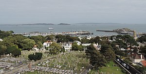
Candie Cemetery
Public cemetery in St Peter Port, Guernsey, Channel Islands
Distance: Approx. 493 meters
Latitude and longitude: 49.45833333,-2.54166667
Candie Cemetery is a public cemetery in St Peter Port, Guernsey.
Weather in this IP's area
few clouds
21 Celsius
20 Celsius
19 Celsius
22 Celsius
1025 hPa
60 %
1025 hPa
1025 hPa
10000 meters
3.09 m/s
150 degree
20 %
05:36:19
20:56:43