Country:
 Australia
Region:
City:
Latitude and Longitude:
Time Zone:
Postal Code:
IP information under different IP Channel
ip-api
Country
Region
City
ASN
Time Zone
ISP
Blacklist
Proxy
Latitude
Longitude
Postal
Route
IPinfo
Country
Region
City
ASN
Time Zone
ISP
Blacklist
Proxy
Latitude
Longitude
Postal
Route
MaxMind
Country
Region
City
ASN
Time Zone
ISP
Blacklist
Proxy
Latitude
Longitude
Postal
Route
Luminati
Country
AURegion
sa
City
adelaide
ASN
Time Zone
Australia/Adelaide
ISP
Ses Astra S.A.
Latitude
Longitude
Postal
db-ip
Country
Region
City
ASN
Time Zone
ISP
Blacklist
Proxy
Latitude
Longitude
Postal
Route
ipdata
Country
Region
City
ASN
Time Zone
ISP
Blacklist
Proxy
Latitude
Longitude
Postal
Route
Popular places and events near this IP address

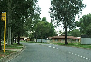
Mawson Lakes, South Australia
Suburb of Adelaide, South Australia
Distance: Approx. 1775 meters
Latitude and longitude: -34.814,138.612
Mawson Lakes is a residential suburb in the City of Salisbury, Adelaide, Australia. Named in honour of Sir Douglas Mawson, it is located in the northern suburbs of Adelaide, approx. 12 kilometres (7.5 mi) north of the Adelaide CBD. Much of the suburb was previously known as The Levels, and was a non-residential area, housing a campus of the University of South Australia.
Endeavour College
Lutheran high school in Adelaide, South Australia, Australia
Distance: Approx. 1567 meters
Latitude and longitude: -34.812,138.619
Endeavour College is a Lutheran high school in Mawson Lakes, a northern suburb of Adelaide, South Australia. Subjects taught include Art & Design, Drama, Music, English, German, Japanese, Mathematics, Physical Education, History, Business Studies, Science (Biology, Chemistry, Physics, Psychology), Material Technology, Multimedia, Geography, Christian Living & Home Economics.

Electoral district of Playford
Electoral district of South Australia
Distance: Approx. 1176 meters
Latitude and longitude: -34.81833333,138.63666667
Playford is a single-member electoral district for the South Australian House of Assembly. Named after the long serving South Australian premier Tom Playford, it is a 22.7 km² suburban electorate in Adelaide's north, taking in the suburbs of Green Fields, Mawson Lakes, Para Hills, Para Hills West, Parafield and Parafield Gardens. Playford was created as a safe Labor seat and was first contested at the 1970 election (when Tom Playford was still alive), where it was won by Labor candidate Terry McRae.

Ingle Farm, South Australia
Suburb of City of Salisbury, South Australia
Distance: Approx. 1801 meters
Latitude and longitude: -34.823,138.646
Ingle Farm is an established, residential suburb, with some parklands, of about 8,500 people in the South Australian capital city of Adelaide. It is located at the base of the Mount Lofty Ranges foothills, around 12 kilometres north-east of Adelaide's central business district. It covers an area of 4.47 km2 with a population density of 19.41 people per hectare in 2001.

Walkley Heights, South Australia
Suburb of Adelaide, South Australia
Distance: Approx. 1912 meters
Latitude and longitude: -34.839,138.638
Walkley Heights is a suburb of Adelaide, South Australia. The suburb is located on land formerly comprising the prison farm for Yatala Labour Prison, and includes fifty-five hectares of land formerly owned by R. M. Williams which was compulsorily acquired during the time of former State Premier Sir Thomas Playford. The suburb (and one adjacent main road) is named after John Walkley, an early pioneer in South Australia The suburb had a population, in 2001, of only 713 increasing to 3,497 by 2016.
Northfield railway station, Adelaide
Former railway station in South Australia, Australia
Distance: Approx. 1676 meters
Latitude and longitude: -34.83953,138.62325
Northfield railway station was located 14.3 km (9 mi) from Adelaide station.
Pooraka, South Australia
Suburb of Adelaide, South Australia
Distance: Approx. 57 meters
Latitude and longitude: -34.82444444,138.62694444
Pooraka ( pə-RACK-ə) is a suburb in Adelaide, South Australia. It is 12 km (7.5 mi) north of the central business district.
District Council of Yatala
Local government area in South Australia
Distance: Approx. 1309 meters
Latitude and longitude: -34.83333333,138.61666667
The District Council of Yatala was a local government area of South Australia established in 1853 and abolished in 1868. The council was named after the Hundred of Yatala which was proclaimed in 1846 in the County of Adelaide, Yatala likely deriving from a Kaurna word 'yartala' referring to the flooded state of the plain either side of Dry Creek after heavy rain. The name was used to describe a large portion of the Adelaide Plains from Port Adelaide in the west to Tea Tree Gully in the east.
Stockade railway station
Former railway station in South Australia, Australia
Distance: Approx. 1881 meters
Latitude and longitude: -34.8415,138.6286
The Stockade railway station, the terminal station of the then Stockade railway line (later the Northfield railway line), was opened on 1 June 1857. It was built to service the colony's prisoner camp, and to transport bluestone mined by convicts to building projects in downtown Adelaide. After a century of service, it was closed in 1961, and the quarry area was later redeveloped as a park.
Stockade Botanic Park
Distance: Approx. 1881 meters
Latitude and longitude: -34.8415,138.6286
Stockade Botanic Park (commonly known also as Stockade Park and Stockade Botanical Park) is a public reserve off Hoods Road in the City of Port Adelaide Enfield's suburb of Northfield. It was formerly associated with a prison quarry but has now been redesigned with water features, an amphitheatre, and picnic areas.
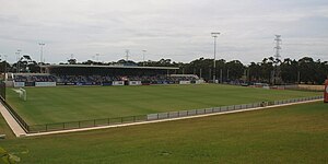
State Centre for Football
Football facility
Distance: Approx. 1808 meters
Latitude and longitude: -34.8397,138.6188
The State Centre for Football, also known as ServiceFM Stadium until at least 2026, is a soccer facility in Gepps Cross, an inner northern suburb of Adelaide, South Australia. The facility consists of two artificial pitches, and the main pitch, which has a seated capacity of 1,000, and a total capacity of 7,000. The stadium hosts many South Australian NPL games, Australia Cup, and African Nations Cup games.
Elder Smith Road
East-west road in northern Adelaide
Distance: Approx. 1793 meters
Latitude and longitude: -34.8091,138.6313
Elder Smith Road is an east-west arterial road in northern Adelaide, South Australia, Australia. It opened in 2007 to connect Main North Road to Salisbury Highway, including a new bridge crossing the Gawler railway line and Adelaide–Port Augusta railway line. It lies entirely in or forms the border of the suburb of Mawson Lakes.
Weather in this IP's area
scattered clouds
6 Celsius
5 Celsius
5 Celsius
7 Celsius
1028 hPa
85 %
1028 hPa
1026 hPa
10000 meters
2.06 m/s
120 degree
40 %
07:12:49
17:30:55