Country:
Region:
City:
Latitude and Longitude:
Time Zone:
Postal Code:
IP information under different IP Channel
ip-api
Country
Region
City
ASN
Time Zone
ISP
Blacklist
Proxy
Latitude
Longitude
Postal
Route
IPinfo
Country
Region
City
ASN
Time Zone
ISP
Blacklist
Proxy
Latitude
Longitude
Postal
Route
MaxMind
Country
Region
City
ASN
Time Zone
ISP
Blacklist
Proxy
Latitude
Longitude
Postal
Route
Luminati
Country
Region
03
City
clark
ASN
Time Zone
Asia/Manila
ISP
Converge ICT Solutions Inc.
Latitude
Longitude
Postal
db-ip
Country
Region
City
ASN
Time Zone
ISP
Blacklist
Proxy
Latitude
Longitude
Postal
Route
ipdata
Country
Region
City
ASN
Time Zone
ISP
Blacklist
Proxy
Latitude
Longitude
Postal
Route
Popular places and events near this IP address
Binmaley
Municipality in Pangasinan, Philippines
Distance: Approx. 4143 meters
Latitude and longitude: 16.03232,120.26904
Binmaley, officially the Municipality of Binmaley (Pangasinan: Baley na Binmaley; Ilocano: Ili ti Binmaley; Tagalog: Bayan ng Binmaley), is a 1st class municipality in the province of Pangasinan, Philippines. According to the 2020 census, it has a population of 86,881 people. Binmaley is 4 kilometres (2.5 mi) from Lingayen and 210 kilometres (130 mi) from Manila.

Lingayen
Municipality in Pangasinan, Philippines
Distance: Approx. 591 meters
Latitude and longitude: 16.01667,120.23333
Lingayen, officially the Municipality of Lingayen ([ˌliŋgɐˈjɛn]; Pangasinan: Baley na Lingayen; Ilocano: Ili ti Lingayen; Tagalog: Bayan ng Lingayen), is a 1st class municipality and capital of the province of Pangasinan, Philippines. According to the 2020 census, it has a population of 107,728 people. It is the capital and the seat of government of the province of Pangasinan.

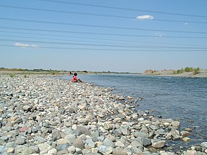
Agno River
River in Luzon, Philippines
Distance: Approx. 3863 meters
Latitude and longitude: 16.03805556,120.2
The Agno River, also known as the Pangasinan River, is a river on the island of Luzon in the Philippines. Traversing the provinces of Benguet, Pangasinan, and Tarlac, it is one of the largest river systems in the country, with a drainage area of 5,952 square kilometres (2,298 sq mi). The river originates in the Cordillera Mountains and empties into the South China Sea via Lingayen Gulf.
Pangasinan State University
Public university in Pangasinan, Philippines
Distance: Approx. 1147 meters
Latitude and longitude: 16.03194444,120.23
Pangasinan State University (Filipino: Pamantasang Pampamahalaan ng Pangasinan), also referred to by its acronym PSU or PangSU,) is a public university in Pangasinan province, Philippines. The university was founded in its current form in 1979, although its origins trace back to the 1920s. PSU is notable for its many locations throughout the province of Pangasinan.

Saints Peter and Paul Parish Church (Calasiao)
Roman Catholic church in Pangasinan, Philippines
Distance: Approx. 2609 meters
Latitude and longitude: 16.036,120.2125
The Saints Peter and Paul Parish Church (Spanish: Iglesia Parroquial de los Santos Pedro y Pablo), commonly known as Calasiao Church, is a baroque church located in Poblacion West, Calasiao, Pangasinan, Philippines. It belongs to the Vicariate of Sts. Peter and Paul under the Ecclesiastical Province of the Roman Catholic Archdiocese of Lingayen-Dagupan.
Pangasinan School of Arts and Trades
Distance: Approx. 1149 meters
Latitude and longitude: 16.03043,120.22601
Pangasinan School of Arts and Trades, also referred to as PSAT, is a government institution of technical vocational education and training higher learning located in Alvear Street, Lingayen, Pangasinan, Philippines. PSAT is duly registered by the Technical Education and Skills Development Authority. All PSAT programs are accredited by the Technical Education and Skills Development Authority (TESDA).

Casa Real (Lingayen)
Distance: Approx. 278 meters
Latitude and longitude: 16.019805,120.230341
Casa Real (Royal House) is one of the oldest public buildings and served as the provincial seat of government of Lingayen, Pangasinan, in the Philippines during the Spanish colonial period. It was where the alcalde mayor held office as the provincial governor and the judge of the Court of First Instance. It was declared a National Landmark by the National Historical Commission of the Philippines and noted it as "an outstanding and unique example of civil architecture from the Spanish and American colonial periods".

Epiphany of Our Lord Co-Cathedral Parish
Roman Catholic church in Pangasinan, Philippines
Distance: Approx. 64 meters
Latitude and longitude: 16.021862,120.231306
The Co-Cathedral Parish of the Epiphany of Our Lord, commonly known as Lingayen Church and formerly Los Tres Reyes or Three Kings Parish, is a historic Catholic church and cathedral in Lingayen, Pangasinan in the Philippines. The church is one of the oldest in the region, founded in 1587 in the same year Saint Dominic Basilica in San Carlos, Pangasinan was also founded. It is famous for its architecture, including a dome designed by Father Miguel Aparicio and its bell tower.

Pangasinan Provincial Capitol
Government Building in Pangasinan, Philippines
Distance: Approx. 1305 meters
Latitude and longitude: 16.033513,120.231519
The Pangasinan Provincial Capitol, on Lingayen Gulf, is the present seat of the government of Pangasinan. It was declared as one of the eight Architectural Treasures of the Philippines by the National Commission for Culture and the Arts. Located in Lingayen, this government building was constructed during the term of the late Governor Daniel Maramba, the "Grand Old Man of Pangasinan".
Colegio del Santissimo Rosario (Lingayen)
Defunct Roman Catholic school in Pangasinan, Philippines
Distance: Approx. 890 meters
Latitude and longitude: 16.021111,120.22361
The Colegio dela Nuestra Señora del Santissimo Rosario (School of Our Lady of the Most Holy Rosary) was an exclusive school run by Dominican sisters for girls. Constructed in 1890, the school occupied one hectare of land and was composed of a dormitory for schoolgirls, a clausura for the nuns, and a chapel.

Urduja House
Residence in Pangasinan, Philippines
Distance: Approx. 1428 meters
Latitude and longitude: 16.03462,120.23231
Urduja House, previously known as Urduja Palace, is the official residence of the governor of Pangasinan. Built across the Pangasinan Provincial Capitol in 1953, it has been home to subsequent governors since as their residence while in the capital.
Narciso Ramos Sports and Civic Center
Sports complex in Pangasinan, Philippines
Distance: Approx. 1330 meters
Latitude and longitude: 16.03192,120.22529
The Narciso Ramos Sports and Civic Center (NRSCC), also known as the Narciso Ramos Sports Complex, is a complex of sports facilities in Lingayen, Pangasinan.
Weather in this IP's area
overcast clouds
31 Celsius
36 Celsius
31 Celsius
31 Celsius
1009 hPa
64 %
1009 hPa
1008 hPa
10000 meters
3.95 m/s
4.41 m/s
326 degree
95 %
05:39:43
18:31:07


