Country:
 The Philippines
Region:
City:
Latitude and Longitude:
Time Zone:
Postal Code:
IP information under different IP Channel
ip-api
Country
Region
City
ASN
Time Zone
ISP
Blacklist
Proxy
Latitude
Longitude
Postal
Route
IPinfo
Country
Region
City
ASN
Time Zone
ISP
Blacklist
Proxy
Latitude
Longitude
Postal
Route
MaxMind
Country
Region
City
ASN
Time Zone
ISP
Blacklist
Proxy
Latitude
Longitude
Postal
Route
Luminati
Country
PHRegion
15
City
baguiocity
ASN
Time Zone
Asia/Manila
ISP
Converge ICT Solutions Inc.
Latitude
Longitude
Postal
db-ip
Country
Region
City
ASN
Time Zone
ISP
Blacklist
Proxy
Latitude
Longitude
Postal
Route
ipdata
Country
Region
City
ASN
Time Zone
ISP
Blacklist
Proxy
Latitude
Longitude
Postal
Route
Popular places and events near this IP address
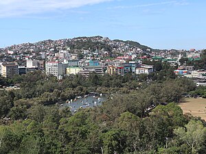
Baguio
Largest highly urbanized city in Benguet, Philippines
Distance: Approx. 501 meters
Latitude and longitude: 16.4119,120.5933
Baguio (UK: BAG-ee-oh, US: BAH-ghee-oh, -OH, Tagalog: [ˈbagjɔ]), officially the City of Baguio (Ibaloi: Siudad ne Bagiw; Ilocano: Siudad ti Baguio; Tagalog: Lungsod ng Baguio), is a 1st class highly urbanized city in the Cordillera Administrative Region, Philippines. It is known as the "Summer Capital of the Philippines", owing to its cool climate since the city is located approximately 4,810 feet (1,470 meters) above mean sea level, often cited as 1,540 meters (5,050 feet) in the Luzon tropical pine forests ecoregion, which also makes it conducive for the growth of mossy plants, orchids and pine trees, to which it attributes its other moniker as the "City of Pines". Baguio was established as a hill station by the United States in 1900 at the site of an Ibaloi village known as Kafagway.
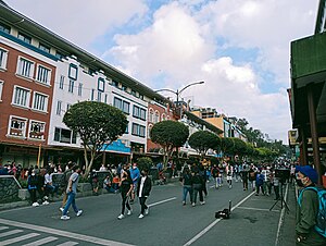
Session Road
Road in Baguio, Philippines
Distance: Approx. 661 meters
Latitude and longitude: 16.41239,120.59766
Session Road is a six-lane 1.7-kilometer (1.1 mi) major road in Baguio, Philippines. The entire road forms part of National Route 231 (N231) of the Philippine highway network.
Saint Louis University (Philippines)
Roman Catholic university in Baguio, Philippines
Distance: Approx. 535 meters
Latitude and longitude: 16.4183,120.5977
Saint Louis University (Spanish: Universidad de San Luis; Filipino: Pamantasan ng San Luis) also referred to by its acronym SLU, is a private Catholic research basic and higher education institution run by the Congregation of the Immaculate Heart of Mary in Baguio, Philippines. It was founded on December 1, 1911, by the CICM Missionaries. Saint Louis University offers programs at the elementary, secondary, undergraduate and graduate levels.
Baguio Central University
Private university in Baguio, Philippines
Distance: Approx. 392 meters
Latitude and longitude: 16.417222,120.596667
Baguio Central University is a private, non-sectarian, basic and higher education institution in Baguio City, Philippines. It offers education to high school and preschool students. It is also known for its vocational courses.
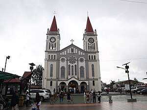
Baguio Cathedral
Roman Catholic church in Baguio, Philippines
Distance: Approx. 700 meters
Latitude and longitude: 16.412744,120.598435
The Our Lady of the Atonement Cathedral, commonly known as Baguio Cathedral, is a Roman Catholic cathedral located at Cathedral Loop adjacent to Session Road in Baguio, the Philippines, and is the see of the Diocese of Baguio. Dedicated to the Blessed Virgin Mary under the title of Our Lady of Atonement, its distinctive exterior, twin spires and stained glass windows make it a popular tourist attraction in Baguio. It served as an evacuation center under the Japanese Occupation during Second World War.
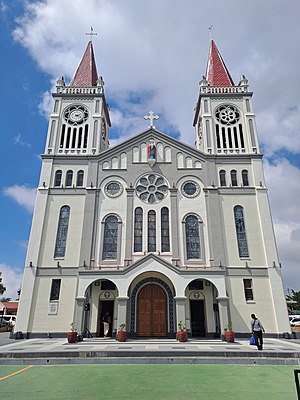
Roman Catholic Diocese of Baguio
Roman Catholic diocese in the Philippines
Distance: Approx. 659 meters
Latitude and longitude: 16.4128,120.598
The Diocese of Baguio (Latin: Dioecesis Baghiopolitana) is a Latin Church suffragan diocese of the Catholic Church in the Philippines comprising the city of Baguio and the province of Benguet on Luzon island in the Philippines. Its see is the Our Lady of Atonement Cathedral in Baguio, Benguet, Cordillera Administrative Region. It was first established in 1952 as the Apostolic Prefecture of Mountain Province, later elevated to an apostolic vicariate in 1948.
Pines City National High School
Public high school in Baguio. Philippines
Distance: Approx. 486 meters
Latitude and longitude: 16.41362,120.58959
Pines City National High School is a public secondary school in Baguio, Philippines. It has a main campus (located on Palma Street), and several annexes and campuses in the city.
University of Baguio
Private university in Baguio, Philippines
Distance: Approx. 484 meters
Latitude and longitude: 16.41542,120.59752
The University of Baguio (UB; Filipino: Pamantasan ng Baguio), formerly Baguio Technical and Commercial Institute (Baguio Tech), is a private, Filipino, multidisciplinary, autonomous university in Baguio, Philippines. It was founded by Fernando Gonzaga Bautista and Rosa Castillo Bautista on August 8, 1948, with 80 students. The student population in 2018 was about 18,000 in its tertiary level.
Gateway Community Church
Church in Baguio CIty, Philippines
Distance: Approx. 546 meters
Latitude and longitude: 16.415,120.598
The Gateway Community Church is a non-denominational church located in Baguio, Philippines .
Saint Louis University International School of Medicine
Medical school in Baguio, Philippines
Distance: Approx. 569 meters
Latitude and longitude: 16.41793,120.59818
The Saint Louis University-International School of Medicine is one of the nine academic units of Saint Louis University, a private, Roman Catholic, CICM university in the Philippines. It is housed at Dr. Jose Rizal Building inside the SLU Main campus adjacent to its partner hospital, the Saint Louis University-Hospital of the Sacred Heart founded a year after the school's foundation in 1976.

University of Baguio Science High School
Private high school in Baguio, Philippines
Distance: Approx. 560 meters
Latitude and longitude: 16.41637,120.59834
The University of Baguio Science High School (UBSHS) is a private, nonsectarian science high school. It is the science department of the University of Baguio and was founded in 1963, predating the Philippine Science High School which was established in 1964. The school is considered a pioneer among private science high schools in Asia.

Maharlika Livelihood Center
Shopping mall in Baguio, Philippines
Distance: Approx. 322 meters
Latitude and longitude: 16.41406,120.59488
Maharlika Livelihood Center is a shopping complex in Baguio, Philippines.
Weather in this IP's area
light rain
16 Celsius
17 Celsius
16 Celsius
16 Celsius
1012 hPa
92 %
1012 hPa
853 hPa
10000 meters
0.44 m/s
0.99 m/s
62 degree
100 %
05:37:41
18:30:15