Country:
 The Philippines
Region:
City:
Latitude and Longitude:
Time Zone:
Postal Code:
IP information under different IP Channel
ip-api
Country
Region
City
ASN
Time Zone
ISP
Blacklist
Proxy
Latitude
Longitude
Postal
Route
IPinfo
Country
Region
City
ASN
Time Zone
ISP
Blacklist
Proxy
Latitude
Longitude
Postal
Route
MaxMind
Country
Region
City
ASN
Time Zone
ISP
Blacklist
Proxy
Latitude
Longitude
Postal
Route
Luminati
Country
PHRegion
03
City
clark
ASN
Time Zone
Asia/Manila
ISP
Converge ICT Solutions Inc.
Latitude
Longitude
Postal
db-ip
Country
Region
City
ASN
Time Zone
ISP
Blacklist
Proxy
Latitude
Longitude
Postal
Route
ipdata
Country
Region
City
ASN
Time Zone
ISP
Blacklist
Proxy
Latitude
Longitude
Postal
Route
Popular places and events near this IP address

Camp John Hay
Mixed-used development in Baguio, Philippines
Distance: Approx. 3920 meters
Latitude and longitude: 16.398912,120.609463
Camp John Hay is a mixed-used development which serves as a tourist destination and forest watershed reservation in Baguio, Philippines which was formerly a military base of the United States Armed Forces.

John Hay Air Station
Former military installation in Baguio, Philippines
Distance: Approx. 3310 meters
Latitude and longitude: 16.3926,120.6193
John Hay Air Station, more commonly known as Camp John Hay, was a military installation in Baguio, Philippines. The site was a major hill station used for rest and recreation, or R&R, for personnel and dependents of the United States Armed Forces in the Philippines as well as United States Department of Defense employees and their dependents. It was last run by the United States Air Force as a communications station.

Mines View Park
Overlook park in Baguio, Philippines
Distance: Approx. 2088 meters
Latitude and longitude: 16.419682,120.627267
Mines View Park is an overlook park on the northeastern outskirts of Baguio in the Philippines. Located on a land promontory 4 kilometres (2.5 mi) from downtown Baguio, the park overlooks the mining town of Itogon, particularly the abandoned gold and copper mines of the Benguet Corporation, and offers a glimpse of the Amburayan Valley. The observation deck is situated below a winding stone-covered stairway close to the parking area.
Baguio City Economic Zone
Distance: Approx. 4385 meters
Latitude and longitude: 16.37983,120.61817
Baguio City Economic Zone is a manufacturing special economic zone (MSEZ) located in the city of Baguio in the Cordillera Administrative Region. It is operated by the Philippine Economic Zone Authority (PEZA), an agency in charge of developing and operating special economic zones in the Philippines. It has a total area of 1,162,497 square metres (116.2497 ha) and 31 locators as of February 2024.

Casa Vallejo
Historic hotel in Baguio, Philippines
Distance: Approx. 4665 meters
Latitude and longitude: 16.40955,120.60052
Casa Vallejo is a historic hotel in Baguio, Philippines. Built in 1909, it is the oldest hotel in the city. It is also recognized as Baguio Centennial Commission as one of the 10 oldest institutions in the city.
Hyatt Terraces Baguio Hotel
Former hotel in Baguio, Philippines
Distance: Approx. 3875 meters
Latitude and longitude: 16.40722222,120.60805556
The Hyatt Terraces Baguio, opened in September of 1976 as the Terraces Plaza Hotel, was a 12-storey hotel located along South Drive in Baguio, Philippines. It was the only five-star International hotel outside the National Capital Region during its time until the hotel was destroyed during the 1990 Luzon earthquake.
Asia Pacific Theological Seminary
Theological seminary in Baguio, Philippines
Distance: Approx. 3032 meters
Latitude and longitude: 16.42836111,120.62294444
Asia Pacific Theological Seminary (APTS) is a theological seminary in Baguio, Philippines, operated by the Assemblies of God. APTS is part of Asia Graduate School of Theology, a consortium of evangelical theological seminaries established by the ATA in 1984 to enable member seminaries to offer higher degrees. According to Wonsuk and Julie Ma, APTS is a "well-respected institution, not only among Evangelicals, but also mainline churches".
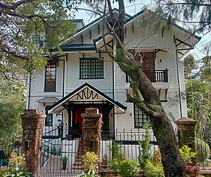
Laperal White House
Landmark in Baguio, Philippines
Distance: Approx. 4217 meters
Latitude and longitude: 16.4111,120.60472
The Laperal Guesthouse, popularly known as Laperal White House, is a building in Baguio, Philippines which housed a museum and is now the home of a new restaurant called Joseph's (owned by the older brother of ABS-CBN News broadcast journalist, Bernadette Sembrano).
Aguinaldo Museum
History museum in Baguio, Philippines
Distance: Approx. 4635 meters
Latitude and longitude: 16.4122,120.60084
The Gen. Emilio Aguinaldo Museum (Filipino: Museo ni Emilio Aguinaldo) or simply known as the Aguinaldo Museum is a history museum in Baguio, Philippines.
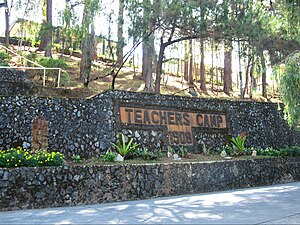
Teachers Camp
Teachers' training center in Baguio, Philippines
Distance: Approx. 3865 meters
Latitude and longitude: 16.41222,120.60806
The Baguio Teachers Camp (BTC), commonly referred to as Teachers Camp, is a teachers' training center and events venue located along Leonard Wood Road in Baguio, Philippines. It is a recognized heritage site by the Baguio city government since 2005 and the national government since 2008. Established as a recreation area for teachers in the 1900s during the American colonial period, the site currently hosts the National Educators Academy of the Philippines (NEAP) of the Department of Education.

Wright Park (Baguio)
Park in Baguio, Philippines
Distance: Approx. 2801 meters
Latitude and longitude: 16.41533333,120.6185
Wright Park is a park in Baguio, Philippines.

Baguio Botanical Garden
Botanical garden in Baguio, Philippines
Distance: Approx. 3345 meters
Latitude and longitude: 16.41456217,120.61319207
The Baguio Botanical Garden, formerly known as Imelda Park, is a botanical garden in Baguio, Philippines, located on Leonard Wood Road between Wright Park and Teacher's Camp.
Weather in this IP's area
overcast clouds
19 Celsius
19 Celsius
19 Celsius
19 Celsius
1012 hPa
94 %
1012 hPa
884 hPa
10000 meters
0.79 m/s
1.16 m/s
350 degree
100 %
05:37:12
18:30:23