Country:
 The Philippines
Region:
City:
Latitude and Longitude:
Time Zone:
Postal Code:
IP information under different IP Channel
ip-api
Country
Region
City
ASN
Time Zone
ISP
Blacklist
Proxy
Latitude
Longitude
Postal
Route
IPinfo
Country
Region
City
ASN
Time Zone
ISP
Blacklist
Proxy
Latitude
Longitude
Postal
Route
MaxMind
Country
Region
City
ASN
Time Zone
ISP
Blacklist
Proxy
Latitude
Longitude
Postal
Route
Luminati
Country
PHRegion
03
City
angelescity
ASN
Time Zone
Asia/Manila
ISP
Converge ICT Solutions Inc.
Latitude
Longitude
Postal
db-ip
Country
Region
City
ASN
Time Zone
ISP
Blacklist
Proxy
Latitude
Longitude
Postal
Route
ipdata
Country
Region
City
ASN
Time Zone
ISP
Blacklist
Proxy
Latitude
Longitude
Postal
Route
Popular places and events near this IP address
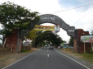
Camiling
Municipality in Tarlac, Philippines
Distance: Approx. 34 meters
Latitude and longitude: 15.6867,120.4131
Camiling, officially the Municipality of Camiling, (Pangasinan: Baley na Camiling; Ilocano: Ili ti Camiling; Tagalog: Bayan ng Camiling) is a 1st class municipality in the province of Tarlac in the Philippines. According to the 2020 census, it has a population of 87,319 people. Camiling is one of the fastest-growing towns of Tarlac when it comes to income and economy.

Bayambang
Municipality in Pangasinan, Philippines
Distance: Approx. 7516 meters
Latitude and longitude: 15.71667,120.35
Bayambang, officially the Municipality of Bayambang (Pangasinan: Baley na Bayambang; Ilocano: Ili ti Bayambang; Tagalog: Bayan ng Bayambang), is a 1st class municipality in the province of Pangasinan, Philippines. According to the 2020 census it has a population of 129,011. It previously included the municipalities of Bautista, Alcala, Santo Tomas, Rosales, Paniqui, Gerona and Camiling.
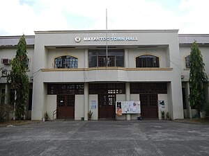
Mayantoc
Municipality in Tarlac, Philippines
Distance: Approx. 8294 meters
Latitude and longitude: 15.6203,120.3775
Mayantoc, officially the Municipality of Mayantoc (Pangasinan: Baley na Mayantoc; Ilocano: Ili ti Mayantoc; Tagalog: Bayan ng Mayantoc), is a 3rd class municipality in the province of Tarlac, Philippines. According to the 2020 census, it has a population of 32,597 people. It is nestled in the foothills of the Zambales Mountains where the Camiling River originates and provides many scenic picnic and swimming sites, making it known as the summer capital of the province.

San Clemente, Tarlac
Municipality in Tarlac, Philippines
Distance: Approx. 6292 meters
Latitude and longitude: 15.7119,120.3603
San Clemente, officially the Municipality of San Clemente (Pangasinan: Baley na San Clemente; Ilocano: Ili ti San Clemente; Tagalog: Bayan ng San Clemente), is a 5th class municipality in the province of Tarlac, Philippines. According to the 2020 census, it has a population of 13,181 people.

Santa Ignacia
Municipality in Tarlac, Philippines
Distance: Approx. 7640 meters
Latitude and longitude: 15.62,120.43
Santa Ignacia, officially the Municipality of Santa Ignacia (Pangasinan: Baley na Santa Ignacia; Ilocano: Ili ti Santa Ignacia; Tagalog: Bayan ng Santa Ignacia), is a 2nd class municipality in the province of Tarlac, Philippines. Santa Ignacia has a total land area of 14,607 hectares (36,095 acres). According to the 2020 census, it has a population of 51,626 people.

Tarlac River
River in Central Luzon, Philippines
Distance: Approx. 8964 meters
Latitude and longitude: 15.75812,120.45124
The Tarlac River is a river in Central Luzon Philippines, it is the longest tributary of the Agno River with a total length of 95.2 km (59.2 mi) covering a drainage area of 1,900 square kilometres (730 sq mi) traversing the provinces of Tarlac and Pangasinan. The river originates around the vicinity of Mount Pinatubo and empties itself into the Agno River at Poponto Swamp located between the boundaries of Tarlac and Pangasinan. It was formerly the site of traditional balsa or bamboo raft riding, until the river was heavily silted by sticky lahar or mud flow brought by the eruption of Mount Pinatubo on June 15, 1991, filling the river with over 10 feet (3.0 m) of lahar.
Tarlac Agricultural University
Public university in Tarlac, Philippines
Distance: Approx. 5810 meters
Latitude and longitude: 15.63444444,120.41472222
Tarlac Agricultural University (TAU), formerly the Tarlac College of Agriculture, is a public university in the province of Tarlac, Philippines. It is mandated to provide professional, technical and instruction for special purposes and to promote research extension services and progressive leadership in agriculture, agricultural education, home technology and other related fields. Its main campus is located in Malacampa, Camiling, Tarlac.
Weather in this IP's area
overcast clouds
26 Celsius
27 Celsius
26 Celsius
26 Celsius
1011 hPa
85 %
1011 hPa
1008 hPa
10000 meters
1.26 m/s
1.77 m/s
178 degree
100 %
05:39:29
18:29:54