Country:
 The Philippines
Region:
City:
Latitude and Longitude:
Time Zone:
Postal Code:
IP information under different IP Channel
ip-api
Country
Region
City
ASN
Time Zone
ISP
Blacklist
Proxy
Latitude
Longitude
Postal
Route
IPinfo
Country
Region
City
ASN
Time Zone
ISP
Blacklist
Proxy
Latitude
Longitude
Postal
Route
MaxMind
Country
Region
City
ASN
Time Zone
ISP
Blacklist
Proxy
Latitude
Longitude
Postal
Route
Luminati
Country
PHRegion
00
City
pasig
ASN
Time Zone
Asia/Manila
ISP
Converge ICT Solutions Inc.
Latitude
Longitude
Postal
db-ip
Country
Region
City
ASN
Time Zone
ISP
Blacklist
Proxy
Latitude
Longitude
Postal
Route
ipdata
Country
Region
City
ASN
Time Zone
ISP
Blacklist
Proxy
Latitude
Longitude
Postal
Route
Popular places and events near this IP address
Baliwag
Component city in Bulacan, Philippines
Distance: Approx. 9511 meters
Latitude and longitude: 14.954,120.901
Baliwag, officially the City of Baliwag (Tagalog: [bɐˈliʊag]; Filipino: Lungsod ng Baliwag, Kapampangan: Lungsod ning Baliwag, also spelled as Baliuag), is a component city in the province of Bulacan, Philippines. According to the 2020 census, it has a population of 168,470 people. Baliwag was founded in 1732 by Augustinian friars and was incorporated by the Spanish Governor-General on May 26, 1733.
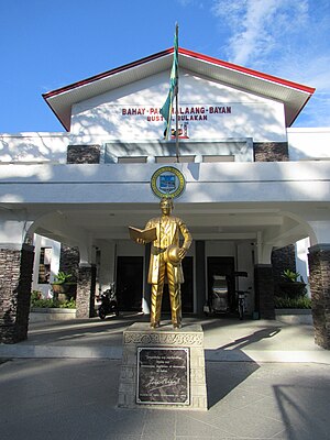
Bustos, Bulacan
Municipality in Bulacan, Philippines
Distance: Approx. 8958 meters
Latitude and longitude: 14.95,120.92
Bustos, officially the Municipality of Bustos (Tagalog: Bayan ng Bustos), is a 1st class municipality in the province of Bulacan, Philippines. According to the 2020 census, it has a population of 77,199 people.

San Ildefonso, Bulacan
Municipality in Bulacan, Philippines
Distance: Approx. 6064 meters
Latitude and longitude: 15.07889,120.94194
San Ildefonso, officially the Municipality of San Ildefonso (Tagalog: Bayan ng San Ildefonso) is a 1st class municipality in the province of Bulacan, Philippines. According to the 2020 census, it has a population of 115,713 people. With the continuous expansion of Metro Manila, the municipality is the northernmost part of Manila's built-up area.

San Rafael, Bulacan
Municipality in Bulacan, Philippines
Distance: Approx. 8616 meters
Latitude and longitude: 14.95,120.97
San Rafael, officially the Municipality of San Rafael (Tagalog: Bayan ng San Rafael, Kapampangan: Balen ning San Rafael), is a 1st class municipality in the province of Bulacan, Philippines. According to the 2020 census, it has a population of 103,097 people. With the continuous expansion of Metro Manila, San Rafael is part of Manila's built-up area which reaches San Ildefonso, Bulacan at its northernmost part.
Bulacan Agricultural State College
Public college in Bulacan, Philippines
Distance: Approx. 5317 meters
Latitude and longitude: 15.072437,120.955962
Bulacan State Agricultural University (BSAU; formerly known as Bulacan Agricultural State College) is an agricultural state college in San Ildefonso, Bulacan, Philippines. It prides itself of being the lone agricultural higher education institution in the province of Bulacan. Its former name is Bulacan National Agricultural State College (BNASC).
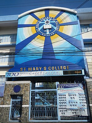
St. Mary's College of Baliuag
Roman Catholic college in Bulacan, Philippines
Distance: Approx. 9394 meters
Latitude and longitude: 14.956,120.8999
St. Mary's College of Baliuag (St. Mary's College, St.

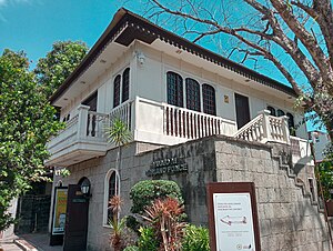
Saint Augustine Parish Church (Baliwag)
Roman Catholic church in Bulacan, Philippines
Distance: Approx. 9446 meters
Latitude and longitude: 14.955,120.90055556
The Diocesan Shrine and Parish of Saint Augustine, commonly known as Baliwag Church, is a Roman Catholic church located in Plaza Naning at the poblacion (town center) of Baliwag, in Bulacan province, Philippines. The church is a parish church of the Diocese of Malolos, which is a suffragan of the Archdiocese of Manila. The parish was established by the Augustinians in 1733 under the patronage of Augustine of Hippo.

Bustos Dam
Dam in Bulacan, Philippines
Distance: Approx. 7597 meters
Latitude and longitude: 14.9569,120.9548
Bustos Dam, also known as Angat Afterbay Regulator Dam, is a small irrigation dam at Bustos, Bulacan is often mistaken by the locals as Angat Dam since it is located close to the nearby town of Angat. The project is located at Barangay Tibagan, Bustos, Bulacan, served by the Angat River. The main dam is about 18 meters above sea level.

Goldenville School of Montessori
Private Montessori school in Bulacan, Philippines
Distance: Approx. 4553 meters
Latitude and longitude: 15.06523,120.94258
Goldenville School of Montessori, Inc. is a private school on the southern part of San Ildefonso, Bulacan, Philippines. It has the most expensive tuition and matriculation fee in San Ildefonso.

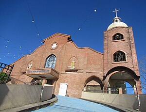
San Juan de Dios Church (San Rafael)
Roman Catholic church in Bulacan, Philippines
Distance: Approx. 7541 meters
Latitude and longitude: 14.958422,120.963135
San Juan de Dios Parish Church, also San Rafael Church, is an 18th-century Roman Catholic church situated in Brgy. Poblacion, in San Rafael, Bulacan, Philippines. It is under the jurisdiction of the Diocese of Malolos.

Bahay na Pula
Former hacienda in San Ildefonso, Bulacan in the Philippines
Distance: Approx. 8029 meters
Latitude and longitude: 15.0964,120.93964
The Bahay na Pula (Tagalog, 'Red House') is a former hacienda in San Ildefonso, Bulacan in the Philippines. The site is remembered for the mass rapes and murders committed by the Imperial Japanese Army during World War II. The Japanese military murdered all of the men and boys in the adjacent Mapaniqui, Candaba, Pampanga, and forced over 100 women and girls into sexual slavery, confining and raping them in the Red House.
Nuestra Señora de la Merced Parish
Roman Catholic church in Pampanga, Philippines
Distance: Approx. 7346 meters
Latitude and longitude: 15.03042,120.8821
Nuestra Señora de la Merced Parish (Filipino: Parokya ng Nuestra Señora de la Merced), is a Roman Catholic church located in Bahay Pare, Candaba, Pampanga in the Philippines. The parish church is under the Roman Catholic Archdiocese of San Fernando, Pampanga and is the home of the Nuestra Señora de la Merced de Pampanga, Emperatriz na Marilag sa Katagalugan ng Pampanga, which is the oldest and original image of the title. Devotees flock to the parish to ask Mary to intercede for their spiritual, mental, and physical health, for their families and studies, and for the increase of vocations to the priesthood and consecrated life.
Weather in this IP's area
light rain
29 Celsius
34 Celsius
29 Celsius
30 Celsius
1007 hPa
72 %
1007 hPa
1004 hPa
10000 meters
3.15 m/s
4.33 m/s
228 degree
100 %
05:38:02
18:27:06