Country:
 The Philippines
Region:
City:
Latitude and Longitude:
Time Zone:
Postal Code:
IP information under different IP Channel
ip-api
Country
Region
City
ASN
Time Zone
ISP
Blacklist
Proxy
Latitude
Longitude
Postal
Route
IPinfo
Country
Region
City
ASN
Time Zone
ISP
Blacklist
Proxy
Latitude
Longitude
Postal
Route
MaxMind
Country
Region
City
ASN
Time Zone
ISP
Blacklist
Proxy
Latitude
Longitude
Postal
Route
Luminati
Country
PHRegion
00
City
pasig
ASN
Time Zone
Asia/Manila
ISP
Converge ICT Solutions Inc.
Latitude
Longitude
Postal
db-ip
Country
Region
City
ASN
Time Zone
ISP
Blacklist
Proxy
Latitude
Longitude
Postal
Route
ipdata
Country
Region
City
ASN
Time Zone
ISP
Blacklist
Proxy
Latitude
Longitude
Postal
Route
Popular places and events near this IP address

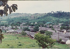
Morong, Bataan
Municipality in Bataan, Philippines
Distance: Approx. 267 meters
Latitude and longitude: 14.68,120.2683
Morong, officially the Municipality of Morong (Tagalog: Bayan ng Morong), is a 3rd class municipality in the province of Bataan, Philippines. According to the 2020 census, it has a population of 35,394 people. The municipality is home to Subic Bay International Airport, Subic Bay Freeport Zone (SBFZ; along with Hermosa also in the province of Bataan, and Olongapo and Subic in Zambales), the Bataan Nuclear Power Plant, and the former Philippine Refugee Processing Center.
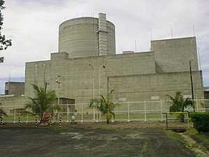
Bataan Nuclear Power Plant
Nuclear power plant in the Philippines
Distance: Approx. 7573 meters
Latitude and longitude: 14.6291,120.314
The Bataan Nuclear Power Plant (BNPP) is a nuclear power plant on the Bataan Peninsula, 100 kilometers (62 mi) west of Manila, Philippines. Completed but never fueled, it is located on a 3.57 km2 (1.38 sq mi) government reservation at Napot Point in Morong, Bataan. It was the Philippines' only attempt at building a nuclear power plant.
Philippine Refugee Processing Center
Refugee camp in Bataan, Philippines
Distance: Approx. 4577 meters
Latitude and longitude: 14.71254444,120.29053333
The Philippine Refugee Processing Center (PRPC) was a large facility near Morong, Bataan, Philippines, which was used as the final stop for Indochinese refugees making their way to permanent resettlement in other nations. It was situated south of Subic Bay and north of the Bataan Nuclear Power Plant.

Japanese minesweeper Banshu Maru No. 52
Distance: Approx. 8129 meters
Latitude and longitude: 14.75,120.28333333
Banshu Maru No.
Ocean Adventure
Distance: Approx. 9640 meters
Latitude and longitude: 14.76452778,120.25275
Ocean Adventure is an open-space marine zoological park in the Morong, Bataan portion of the Subic Special Economic and Freeport Zone in the Philippines.
Subic Bay Space Center
Distance: Approx. 9059 meters
Latitude and longitude: 14.75919444,120.27980556
The Subic Bay Space Center (SCC) also known as the Subic Bay Teleport is a ground station at the Subic Bay Free Port in Morong, Bataan, Philippines. It is currently operated by ABS. The ground station was built in 1996 as the Mabuhay Satellite Space Center by the Mabuhay Philippines Satellite Corporation (MPSC), a consortium of Philippine telecommunications companies. It was built to manage the operations of Agila-1; the first Philippine-owned satellite.
Weather in this IP's area
scattered clouds
30 Celsius
36 Celsius
30 Celsius
30 Celsius
1010 hPa
74 %
1010 hPa
1009 hPa
10000 meters
2.06 m/s
340 degree
40 %
05:41:33
18:29:00