Country:
 Italy
ItalyRegion:
City:
Latitude and Longitude:
Time Zone:
Postal Code:
IP information under different IP Channel
ip-api
Country
Region
City
ASN
Time Zone
ISP
Blacklist
Proxy
Latitude
Longitude
Postal
Route
IPinfo
Country
Region
City
ASN
Time Zone
ISP
Blacklist
Proxy
Latitude
Longitude
Postal
Route
MaxMind
Country
Region
City
ASN
Time Zone
ISP
Blacklist
Proxy
Latitude
Longitude
Postal
Route
Luminati
Country
ITRegion
55
City
foligno
ASN
Time Zone
Europe/Rome
ISP
Connesi s.p.a.
Latitude
Longitude
Postal
db-ip
Country
Region
City
ASN
Time Zone
ISP
Blacklist
Proxy
Latitude
Longitude
Postal
Route
ipdata
Country
Region
City
ASN
Time Zone
ISP
Blacklist
Proxy
Latitude
Longitude
Postal
Route
Popular places and events near this IP address

Foligno
Comune in Umbria, Italy
Distance: Approx. 674 meters
Latitude and longitude: 42.95,12.7
Foligno (Italian pronunciation: [foˈliɲɲo]; Southern Umbrian: Fuligno) is an ancient town of Italy in the province of Perugia in east central Umbria, on the Topino river where it leaves the Apennines and enters the wide plain of the Clitunno river system. It is located 40 kilometres (25 miles) south-east of Perugia, 10 km (6 mi) north-north-west of Trevi and 6 km (4 mi) south of Spello. While Foligno is an active bishopric, one of its civil parishes, San Giovanni Profiamma, is the historical site of the former bishopric of Foro Flaminio, which remains a Latin Catholic titular see.
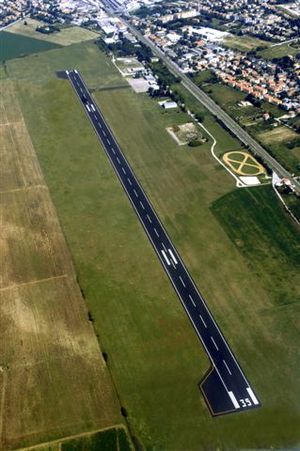
Foligno Airport
Airport
Distance: Approx. 1445 meters
Latitude and longitude: 42.93277778,12.71
Foligno Airport (ICAO: LIAF) is an airport serving the Italian city of Foligno in the Umbria region. It is used for general aviation, school, business jet aviation, charter aviation and cargo. It will be used as national base of Civil defense aviation.
Stadio Enzo Blasone
Distance: Approx. 1292 meters
Latitude and longitude: 42.95333333,12.69166667
The Stadio comunale Enzo Blasone is a multi-use stadium in Foligno, Italy. It is currently used mostly for football matches and is the home stadium of Foligno Calcio. It holds 4.650.
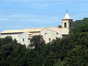
Sassovivo Abbey
Frazione in Umbria, Italy
Distance: Approx. 5154 meters
Latitude and longitude: 42.95666667,12.76194444
The Abbey of Sassovivo is a Benedictine monastery in Umbria in central Italy. Administratively, it is a frazione of the comune of Foligno.

Giostra della Quintana
Distance: Approx. 944 meters
Latitude and longitude: 42.95188,12.70538
The Giostra della Quintana was a historical jousting tournament in Foligno, central Italy. It was revived as a modern festival in 1946. The tournament event takes place in June (1st Challenge) during a Saturday night and September (the counter-challenge) the 2nd or 3rd Sunday of September, and is proceeded each time by a festival with a 17th-century costumed parade.

Roman Catholic Diocese of Foligno
Roman Catholic diocese in Italy
Distance: Approx. 674 meters
Latitude and longitude: 42.95,12.7
The Diocese of Foligno (Latin: Dioecesis Fulginatensis) is a Latin Church ecclesiastical territory or diocese of the Catholic Church in Umbria, Italy. It is a suffragan diocese in the ecclesiastical province of the metropolitan Archdiocese of Perugia-Città della Pieve.
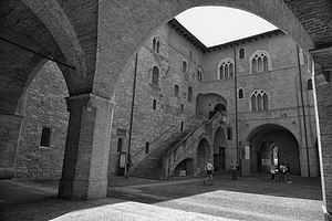
Palazzo Trinci
Patrician residence in the center of Foligno, italy
Distance: Approx. 1241 meters
Latitude and longitude: 42.955,12.70361111
The Trinci Palace is a patrician residence in the center of Foligno, central Italy. It houses an archaeological museum, the city's picture gallery, a multimedia museum of Tournaments and Jousts and the Civic Museum.
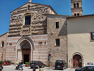
Foligno Cathedral
Distance: Approx. 1391 meters
Latitude and longitude: 42.95638889,12.70333333
Foligno Cathedral (Italian: Basilica Cattedrale di San Feliciano; Duomo di Foligno) is a Catholic cathedral situated on the Piazza della Repubblica in the center of Foligno, Italy. The cathedral, built on the site of an earlier basilica, is dedicated to the patron saint of the city, the martyr Felician of Foligno (San Feliciano), who was buried here in 251 AD. It is the seat of the Bishop of Foligno. It contains the cathedra for the Diocese of Foligno.
San Giacomo, Foligno
Distance: Approx. 1651 meters
Latitude and longitude: 42.9588,12.7025
San Giacomo is a Gothic-style, Roman Catholic church located at the Piazza San Giacomo, Foligno, Italy.
Oratory of Nunziatella, Foligno
Distance: Approx. 1383 meters
Latitude and longitude: 42.9561,12.70494
The Oratorio della Nunziatella is a 15th-century Renaissance-style oratory in Foligno, region of Umbria, Italy. The oratory is located near the 18th-century Chiesa del Suffragio and is named after the Virgin of the Annunciation, considered in those days to be the patron saint of the city. It was restored in the 19th century.

Foligno railway station
Railway station in Foligno, Italy
Distance: Approx. 1420 meters
Latitude and longitude: 42.95444444,12.71111111
Foligno railway station (Italian: Stazione di Foligno) serves the town and comune of Foligno, in the region of Umbria, central Italy. It is also the most important railway junction in Umbria. Opened in 1866, it forms part of the Ancona–Orte railway, and is the southeastern terminus of the Foligno–Terontola railway, which links Florence with Rome.
Vescia
Distance: Approx. 5106 meters
Latitude and longitude: 42.98333333,12.73333333
Vescia was an ancient city of the Ausones (a subgroup of the Aurunci), in what is now central-southern Italy, which was part of the so-called Auruncan Pentapolis and was destroyed by the Romans in 340 BC. It was a fortified center, located perhaps on the left shore of the Garigliano river, in the current comuni of Cellole and Sessa Aurunca, where remains of pre-Romans walls have been found. According to some sources, it was located on the Monte Massico, where there also ancient remains including a subterranean aqueduct and large mosaic pavements. Two Latin inscriptions referring to Vescia, dating to 211-212 AD, have been found in Castelforte, Formia, in the southern province of Latina.
Weather in this IP's area
clear sky
30 Celsius
33 Celsius
29 Celsius
31 Celsius
1016 hPa
63 %
1016 hPa
991 hPa
10000 meters
1.87 m/s
1.51 m/s
265 degree
05:55:11
20:35:58