Country:
 Gibraltar
Region:
City:
Latitude and Longitude:
Time Zone:
Postal Code:
IP information under different IP Channel
ip-api
Country
Region
City
ASN
Time Zone
ISP
Blacklist
Proxy
Latitude
Longitude
Postal
Route
IPinfo
Country
Region
City
ASN
Time Zone
ISP
Blacklist
Proxy
Latitude
Longitude
Postal
Route
MaxMind
Country
Region
City
ASN
Time Zone
ISP
Blacklist
Proxy
Latitude
Longitude
Postal
Route
Luminati
Country
 IM
IMASN
Time Zone
Europe/Isle_of_Man
ISP
CL-1379-14537
Latitude
Longitude
Postal
db-ip
Country
Region
City
ASN
Time Zone
ISP
Blacklist
Proxy
Latitude
Longitude
Postal
Route
ipdata
Country
Region
City
ASN
Time Zone
ISP
Blacklist
Proxy
Latitude
Longitude
Postal
Route
Popular places and events near this IP address

Gibraltar National Day
Distance: Approx. 31 meters
Latitude and longitude: 36.144802,-5.352923
Gibraltar National Day, celebrated annually on 10 September, is the official national day of the British overseas territory of Gibraltar. The day commemorates Gibraltar's first sovereignty referendum of 1967, in which Gibraltarian voters were asked whether they wished to either pass under Spanish sovereignty, or remain under British sovereignty, with institutions of self-government.

North Bastion, Gibraltar
Distance: Approx. 135 meters
Latitude and longitude: 36.145904,-5.352799
The North Bastion, formerly the Baluarte San Pablo (St. Paul's Bastion) was part of the fortifications of Gibraltar, in the north of the peninsula, protecting the town against attack from the mainland of Spain. The bastion was based on the older Giralda tower, built in 1309.
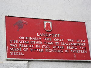
Landport (Gibraltar)
Distance: Approx. 115 meters
Latitude and longitude: 36.14518,-5.35147
The Landport (Spanish: Puerta de Tierra) is a gate into the territory of Gibraltar. It was originally the only entrance to the fortification from the land and so was heavily fortified and guarded.

Grand Casemates Square
Square in Gibraltar
Distance: Approx. 21 meters
Latitude and longitude: 36.1448,-5.3528
Grand Casemates Square (colloquially Casemates Square or Casemates) is the larger of the two main squares within the city centre of Gibraltar (the other being John Mackintosh Square). The square takes its name from the British-built Grand Casemates, a casemate and bombproof barracks at the northern end of the square completed in 1817. Located at the northern end of Main Street, the square is lined with numerous pubs, bars and restaurants and acts as the gateway into Gibraltar's city centre for most tourists.

Montagu Bastion
Distance: Approx. 173 meters
Latitude and longitude: 36.145291,-5.354376
The Montagu Bastion is one of many bastions which were designed to protect Gibraltar. Montagu was joined to Orange Bastion by a curtain wall known as Montagu Curtain and this bastion was protected by the Montagu Counterguard.

Bomb Proof Barracks and Battery
Distance: Approx. 170 meters
Latitude and longitude: 36.145096,-5.35077
Bomb Proof Battery was an artillery battery near Bomb Proof Barracks in the British Overseas Territory of Gibraltar. The battery was located at the south end of the King's Lines on the north-west face of the Rock of Gibraltar. It comprised a casemated battery built on two levels, each of which had two embrasures built into the old Spanish defences constructed above the then Puerta de Villavieja some time in the 16th century.

Couvreport Battery
Artillery battery in Gibraltar
Distance: Approx. 156 meters
Latitude and longitude: 36.145489,-5.35116
Couvreport Battery is an artillery battery in the British Overseas Territory of Gibraltar.

Grand Battery, Gibraltar
Distance: Approx. 90 meters
Latitude and longitude: 36.145402,-5.352102
Grand Battery is an artillery battery in the British Overseas Territory of Gibraltar. To the west of the grand battery was a very formidable flank which was considered to have been a "great annoyance to the besiegers." Known as the Muralla de San Bernando (English: St. Bernard's Wall) during Gibraltar's Spanish period, it was fully adapted to mount cannon facing the isthmus with the old Moorish archery towers being pulled down and replaced by bastions.
Barcina Gate
Distance: Approx. 143 meters
Latitude and longitude: 36.1457,-5.3536
Barcina Gate was a city gate in the British Overseas Territory of Gibraltar. It was located near the port and formed part of the walls, towers and one of three separate access gates which were later named Barcina by the Spanish. Henrique de Guzman was hanged on one of the turrets of the gate here.

Granada Gate
Distance: Approx. 131 meters
Latitude and longitude: 36.144705,-5.351144
Granada Gate was a city gate in the British Overseas Territory of Gibraltar. It was the main entry point by land to the old town of Gibraltar.

Castle Batteries
Series of artillery batteries in Gibraltar
Distance: Approx. 106 meters
Latitude and longitude: 36.145063,-5.351505
Castle Batteries are a series of artillery batteries that are part of the Northern Defences of the British Overseas Territory of Gibraltar. The batteries descend from the Moorish Castle to end at the sixth and seven batteries which are known as Crutchett's Batteries. There are brick vaulted bombproof rooms (casemates) under Crutchets Battery.
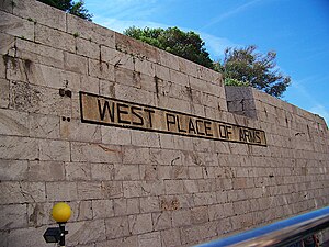
West Place of Arms
Distance: Approx. 180 meters
Latitude and longitude: 36.146283,-5.353014
The West Place of Arms is a place-of-arms in the British Overseas Territory of Gibraltar that was originally used as a troop assembly point. It is located in the gap between the North Bastion and its Counterguard, a structure built in 1804. The Counterguard provided defensive cover for the West Place of Arms, which was also fortified by a ditch into which a large caponier projected.
Weather in this IP's area
scattered clouds
24 Celsius
25 Celsius
24 Celsius
24 Celsius
1012 hPa
88 %
1012 hPa
1012 hPa
10000 meters
3.09 m/s
50 degree
35 %
07:24:39
21:30:56