Country:
 Russian Federation
Region:
City:
Latitude and Longitude:
Time Zone:
Postal Code:
IP information under different IP Channel
ip-api
Country
Region
City
ASN
Time Zone
ISP
Blacklist
Proxy
Latitude
Longitude
Postal
Route
IPinfo
Country
Region
City
ASN
Time Zone
ISP
Blacklist
Proxy
Latitude
Longitude
Postal
Route
MaxMind
Country
Region
City
ASN
Time Zone
ISP
Blacklist
Proxy
Latitude
Longitude
Postal
Route
Luminati
Country
RURegion
niz
City
nizhniynovgorod
ASN
Time Zone
Europe/Moscow
ISP
Rostelecom
Latitude
Longitude
Postal
db-ip
Country
Region
City
ASN
Time Zone
ISP
Blacklist
Proxy
Latitude
Longitude
Postal
Route
ipdata
Country
Region
City
ASN
Time Zone
ISP
Blacklist
Proxy
Latitude
Longitude
Postal
Route
Popular places and events near this IP address

GAZ
Russian manufacturer of commercial vehicles
Distance: Approx. 8849 meters
Latitude and longitude: 56.24644444,43.88988333
GAZ or Gorkovsky avtomobilny zavod (Russian: ГАЗ or Го́рьковский автомоби́льный заво́д, lit. 'Gorky Automobile Plant') is a Russian automotive manufacturer located in Nizhny Novgorod, formerly known as Gorky (Горький) (1932–1990). It is the core subsidiary of GAZ Group Holding, which is itself part of Basic Element industrial group.
Gavrilovka, Dzerzhinsk, Nizhny Novgorod Oblast
Urban-type settlement in Nizhny Novgorod Oblast, Russia
Distance: Approx. 3424 meters
Latitude and longitude: 56.22944,43.71194
Gavrilovka (Russian: Гаври́ловка) is an urban locality (a work settlement) under the administrative jurisdiction of the city of oblast significance of Dzerzhinsk in Nizhny Novgorod Oblast, Russia, located 28 kilometers (17 mi) west of Nizhny Novgorod. Population: 803 (2010 Russian census); 712 (2002 Census); 740 (1989 Soviet census).
Gorbatovka
Urban-type settlement in Nizhny Novgorod Oblast, Russia
Distance: Approx. 906 meters
Latitude and longitude: 56.25555556,43.73333333
Gorbatovka (Russian: Горба́товка) is an urban locality (a work settlement) under the administrative jurisdiction of the city of oblast significance of Dzerzhinsk in Nizhny Novgorod Oblast, Russia, located 23 kilometers (14 mi) west of Nizhny Novgorod, in the vicinity of the Nizhny Novgorod International Airport. Population: 3,378 (2010 Russian census); 3,321 (2002 Census); 4,452 (1989 Soviet census).

Strigino International Airport
Airport
Distance: Approx. 3542 meters
Latitude and longitude: 56.23,43.78666667
Strigino Airport (Russian: Аэропорт Стригино (IATA: GOJ, ICAO: UWGG)) (also referred to as Nizhny Novgorod International Airport (Russian: Международный аэропорт Нижний Новгород)) is the international airport serving the city of Nizhny Novgorod, Russia. It is located on the outskirts of the city's Avtozavodsky District, 14 km (8.5 mi) southwest of city centre. Strigino is responsible for serving the 3,281,000 residents of the Nizhny Novgorod Oblast.
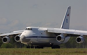
Sormovo Airfield
Airport in Moskovsky District, Nizhny Novgorod
Distance: Approx. 7837 meters
Latitude and longitude: 56.31833333,43.795
Sormovo (or Gorkiy Sormovo) is an airfield in Russia, located on the outskirts of Nizhny Novgorod, some 8 km (5.0 mi) from the center city, just west of the Sokol Aircraft Plant. Legally, it is within the city's Moskovsky District (Московский район), but it is commonly referred to by the name of the much better-known neighborhood of Sormovo, which is to the north of the airfield. Moreover, between 1956 and 1970 the airfield (and all of today's Moskovsky District) was in fact part of the Sormovsky District.
Konovalenko Sports Palace
Distance: Approx. 7097 meters
Latitude and longitude: 56.24718,43.861564
Konovalenko Sports Palace is an indoor sporting arena located in Nizhny Novgorod, Russia. The capacity of the arena is 4,300 and opened in 1967. It was the home arena of the Torpedo Nizhny Novgorod ice hockey team of the Russian Super League until the Trade Union Sport Palace was renovated and expanded in 2007.
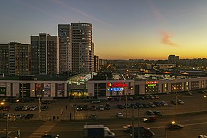
Avtozavodsky City District, Nizhny Novgorod
District in Nizhny Novgorod Oblast, Russia
Distance: Approx. 5100 meters
Latitude and longitude: 56.2336,43.8219
Avtozavodsky City District (Russian: Автозаво́дский райо́н, lit. 'District of the Automobile Plant') or Avtozavod (Russian: Автозавод, lit. 'Autoplant') is one of the eight districts of the city of Nizhny Novgorod, Russia. It is located in the southwest of the Lower City of Nizhny Novgorod, on the low left bank of the Oka River and has a land border with Leninsky City District to the north. It is also connected by the Myza Bridge with Prioksky City District in the Upper City (the right bank of the Oka).

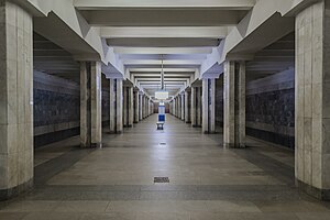
Park Kultury (Nizhny Novgorod Metro)
Nizhny Novgorod Metro Station
Distance: Approx. 6923 meters
Latitude and longitude: 56.24222222,43.8575
Park Kultury (Russian: Парк культу́ры) is the southern terminus of the Avtozavodskaya line of the Nizhny Novgorod Metro. The station opened on 15 November 1989 in the third phase on construction along with Kirovskaya station.
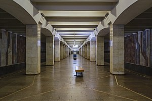
Kirovskaya (Nizhny Novgorod Metro)
Nizhny Novgorod Metro Station
Distance: Approx. 8125 meters
Latitude and longitude: 56.24777778,43.87833333
Kirovskaya (Russian: Кировская) is a station on the Avtozavodskaya line of the Nizhny Novgorod Metro. It opened on 15 November 1989 along with Park Kultury as part of the Metro's third phase. It is in the Avtozavodsky district of Nizhny Novgorod at the intersection of Prospekt Lenina and Prospekt Kirova, the street for which the station is named.
Komsomolskaya (Nizhny Novgorod Metro)
Nizhny Novgorod Metro Station
Distance: Approx. 8825 meters
Latitude and longitude: 56.2525,43.89
Komsomolskaya (Russian: Комсомольская) is a station on the Avtozavodskaya line of the Nizhny Novgorod Metro. The station opened on 8 August 1987 along with Avtozavodskaya station. Like Avtozavodskaya, it is adjacent to the massive GAZ automobile factory in the Avtozavodsky district of Nizhny Novgorod.
Moskovsky City District, Nizhny Novgorod
District in Nizhny Novgorod Oblast, Russia
Distance: Approx. 9562 meters
Latitude and longitude: 56.2667,43.9
Moskovsky City District (Russian: Московский район), is one of the eight districts of the city of Nizhny Novgorod, Russia. Moskovsky District had existed since 1970. Between 1956 and 1970, the territory of today's Moskovsky District was part of the Sormovsky City District, meaning that during that time the Sormovo Airfield was actually within the Sormovsky District.
Petryaevka railway station
Railway station in Russia
Distance: Approx. 3208 meters
Latitude and longitude: 56.2525,43.79916667
Petryaevka is a railway station in Petryaevka, Nizhny Novgorod Oblast, Russia.
Weather in this IP's area
broken clouds
17 Celsius
17 Celsius
17 Celsius
17 Celsius
998 hPa
94 %
998 hPa
988 hPa
10000 meters
2 m/s
220 degree
75 %
04:04:18
20:18:23