Country:
 Russian Federation
Region:
City:
Latitude and Longitude:
Time Zone:
Postal Code:
IP information under different IP Channel
ip-api
Country
Region
City
ASN
Time Zone
ISP
Blacklist
Proxy
Latitude
Longitude
Postal
Route
IPinfo
Country
Region
City
ASN
Time Zone
ISP
Blacklist
Proxy
Latitude
Longitude
Postal
Route
MaxMind
Country
Region
City
ASN
Time Zone
ISP
Blacklist
Proxy
Latitude
Longitude
Postal
Route
Luminati
Country
RURegion
niz
City
nizhniynovgorod
ASN
Time Zone
Europe/Moscow
ISP
Rostelecom
Latitude
Longitude
Postal
db-ip
Country
Region
City
ASN
Time Zone
ISP
Blacklist
Proxy
Latitude
Longitude
Postal
Route
ipdata
Country
Region
City
ASN
Time Zone
ISP
Blacklist
Proxy
Latitude
Longitude
Postal
Route
Popular places and events near this IP address

Gorodets, Nizhny Novgorod Oblast
Town in Nizhny Novgorod Oblast, Russia
Distance: Approx. 8610 meters
Latitude and longitude: 56.65,43.48333333
Gorodets (Russian: Городе́ц) is a town and the administrative center of Gorodetsky District in Nizhny Novgorod Oblast, Russia, located on the left bank of the Volga River, 53 kilometers (33 mi) northwest of Nizhny Novgorod, the administrative center of the oblast. Population: 30,658 (2010 Russian census); 32,442 (2002 Census); 34,210 (1989 Soviet census); 34,000 (1970).

Zavolzhye, Nizhny Novgorod Oblast
Town in Nizhny Novgorod Oblast, Russia
Distance: Approx. 4690 meters
Latitude and longitude: 56.65,43.4
Zavolzhye (Russian: Заво́лжье) is a town in Gorodetsky District of Nizhny Novgorod Oblast, Russia, located on the right bank of the Volga River, opposite Gorodets, the administrative centre of the district, and 56 kilometers (35 mi) northwest of Nizhny Novgorod, the administrative center of the oblast. Population: 40,460 (2010 Russian census); 43,971 (2002 Census); 44,630 (1989 Soviet census).
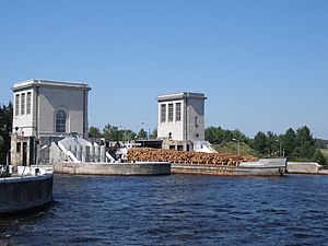
Nizhny Novgorod Hydroelectric Station
Distance: Approx. 5863 meters
Latitude and longitude: 56.650187,43.428955
The Nizhny Novgorod Hydroelectric Station or Nizhny Novgorod GES (Russian: Нижегоро́дская ГЭС) is a hydroelectric station on the Volga river. Located near Zavolzhye, Nizhny Novgorod Oblast, it belongs to the Volga-Kama Cascade of dams.

Gorodetsky District
District in Nizhny Novgorod Oblast, Russia
Distance: Approx. 8610 meters
Latitude and longitude: 56.65,43.48333333
Gorodetsky District (Russian: Городе́цкий райо́н) is an administrative district (raion), one of the forty in Nizhny Novgorod Oblast, Russia. Municipally, it is incorporated as Gorodetsky Municipal District. It is located in the west of the oblast.
Pervomaysky, Gorodetsky District, Nizhny Novgorod Oblast
Urban-type settlement in Nizhny Novgorod Oblast, Russia
Distance: Approx. 190 meters
Latitude and longitude: 56.6134,43.3602
Pervomaysky (Russian: Первома́йский) is an urban locality (an urban-type settlement) in Gorodetsky District of Nizhny Novgorod Oblast, Russia. Population: 1,470 (2010 Russian census); 1,105 (2002 Census); 1,136 (1989 Soviet census).
Weather in this IP's area
scattered clouds
15 Celsius
15 Celsius
15 Celsius
15 Celsius
998 hPa
95 %
998 hPa
989 hPa
10000 meters
0.25 m/s
1.27 m/s
11 degree
49 %
04:03:55
20:21:53