Country:
 Russian Federation
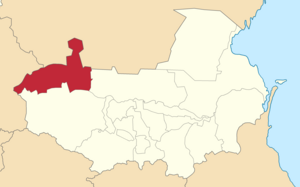
Region:
City:
Latitude and Longitude:
Time Zone:
Postal Code:
IP information under different IP Channel
ip-api
Country
Region
City
ASN
Time Zone
ISP
Blacklist
Proxy
Latitude
Longitude
Postal
Route
IPinfo
Country
Region
City
ASN
Time Zone
ISP
Blacklist
Proxy
Latitude
Longitude
Postal
Route
MaxMind
Country
Region
City
ASN
Time Zone
ISP
Blacklist
Proxy
Latitude
Longitude
Postal
Route
Luminati
Country
RURegion
sta
City
stavropol
ASN
Time Zone
Europe/Moscow
ISP
Rostelecom
Latitude
Longitude
Postal
db-ip
Country
Region
City
ASN
Time Zone
ISP
Blacklist
Proxy
Latitude
Longitude
Postal
Route
ipdata
Country
Region
City
ASN
Time Zone
ISP
Blacklist
Proxy
Latitude
Longitude
Postal
Route
Popular places and events near this IP address

Pyatigorsk
City in Stavropol Krai, Russia
Distance: Approx. 602 meters
Latitude and longitude: 44.05,43.06666667
Pyatigorsk (Russian: Пятиго́рск; Circassian: Псыхуабэ, Psıxwabæ) is a city in Stavropol Krai, Russia located on the Podkumok River, about 20 kilometers (12 mi) from the town of Mineralnye Vody, which has an international airport, and about 45 kilometers (28 mi) from Kislovodsk. Since January 19, 2010, it has been the administrative center of the North Caucasian Federal District of Russia. Population: 142,511 (2010 Russian census); 140,559 (2002 Census); 129,499 (1989 Soviet census).

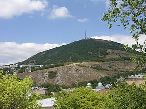
Beshtau
Mountain in Stavropol Krai, Russia
Distance: Approx. 4749 meters
Latitude and longitude: 44.07683889,43.0149
Beshtau (Russian: Бештау, from Turkic beş 'five' and tau 'mountain') is an isolated five-domed igneous mountain (volcano) in the northern vicinity of Pyatigorsk (after the Russian term Pyatigorye 'area of five mountains') in the Northern Caucasus. Its height is 1,401 m (4,596 ft). The slopes are forested with ash, oak, hornbeam, and beech deciduous forests, and the summit is treeless.

Lermontov (town)
Town in Stavropol Krai, Russia
Distance: Approx. 9717 meters
Latitude and longitude: 44.11666667,42.98333333
Lermontov (Russian: Ле́рмонтов) is a town in Stavropol Krai, Russia, located on the mountainside of Beshtau. Population: 22,541 (2010 Russian census); 22,964 (2002 Census); 20,772 (1989 Soviet census); 16,500 (1973).

Central Stadium (Pyatigorsk)
Sports venue in Pyatigorsk, Russia
Distance: Approx. 1984 meters
Latitude and longitude: 44.03110833,43.06414167
Tsentral'ny Stadium is a multi-purpose stadium in Pyatigorsk, Russia. Built in 1966, it was called Trud Stadium until 2001. It is currently used mostly for football matches and is the home stadium of FC Mashuk-KMV Pyatigorsk.
Mashuk
Distance: Approx. 2369 meters
Latitude and longitude: 44.0508889,43.08883334
Mashuk is a mountain in Russia, in the North Caucasus. Mashuk is notable for being where Russian poet Mikhail Lermontov had his famous duel with Nikolai Martynov near Pyatigorsk.
Goryachevodsky
Urban-type settlement in Stavropol Krai, Russia
Distance: Approx. 4888 meters
Latitude and longitude: 44.03333333,43.11666667
Goryachevodsky (Russian: Горячево́дский) is an urban locality (a settlement) under the administrative jurisdiction of the city of krai significance of Pyatigorsk in Stavropol Krai, Russia, located at the confluence of the Podkumok and Yutsa Rivers. Population: 36,967 (2010 Russian census); 34,456 (2002 Census); 29,706 (1989 Soviet census). As of the 2010 Census, it was Russia's most populous urban locality that did not have a town status.
Inozemtsevo
Settlement in Stavropol Krai, Russia
Distance: Approx. 6579 meters
Latitude and longitude: 44.1,43.1
Inozemtsevo (Russian: Иноземцево) is an urban locality (a settlement) under the administrative jurisdiction of the town of oblast significance of Zheleznovodsk in Stavropol Krai, Russia. Population: 28,398 (2010 Russian census); 27,110 (2002 Census); 21,358 (1989 Soviet census).
Svobody
Urban-type settlement in Stavropol Krai, Russia
Distance: Approx. 3045 meters
Latitude and longitude: 44.0225,43.0708
Svobody (Russian: Свободы) is an urban locality (an urban-type settlement) in Stavropol Krai, in southern Russia. Population: 18,042 (2010 Russian census); 17,349 (2002 Census); 15,190 (1989 Soviet census).
Pyatigorsky otdel
Otdel in Caucasus, Russian Empire
Distance: Approx. 602 meters
Latitude and longitude: 44.05,43.06666667
The Pyatigorsky otdel was a Cossack district (otdel) of the Terek oblast of the Caucasus Viceroyalty of the Russian Empire. The area of the Pyatigorsky otdel makes up part of the North Caucasian Federal District of Russia. The district was eponymously named for its administrative center, Pyatigorsk.
Weather in this IP's area
clear sky
28 Celsius
27 Celsius
28 Celsius
28 Celsius
1014 hPa
26 %
1014 hPa
953 hPa
10000 meters
4 m/s
130 degree
04:52:37
19:35:38