Country:
 Russian Federation
Region:
City:
Latitude and Longitude:
Time Zone:
Postal Code:
IP information under different IP Channel
ip-api
Country
Region
City
ASN
Time Zone
ISP
Blacklist
Proxy
Latitude
Longitude
Postal
Route
IPinfo
Country
Region
City
ASN
Time Zone
ISP
Blacklist
Proxy
Latitude
Longitude
Postal
Route
MaxMind
Country
Region
City
ASN
Time Zone
ISP
Blacklist
Proxy
Latitude
Longitude
Postal
Route
Luminati
Country
RUASN
Time Zone
Europe/Moscow
ISP
Rostelecom
Latitude
Longitude
Postal
db-ip
Country
Region
City
ASN
Time Zone
ISP
Blacklist
Proxy
Latitude
Longitude
Postal
Route
ipdata
Country
Region
City
ASN
Time Zone
ISP
Blacklist
Proxy
Latitude
Longitude
Postal
Route
Popular places and events near this IP address
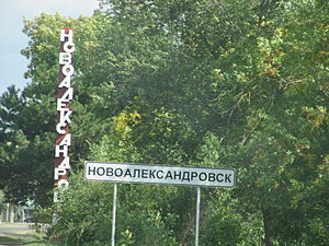
Novoalexandrovsk
Town in Stavropol Krai, Russia
Distance: Approx. 1143 meters
Latitude and longitude: 45.5,41.23333333
Novoalexandrovsk (Russian: Новоалекса́ндровск) is a town and the administrative center of Novoalexandrovsky District in Stavropol Krai, Russia, located on the bank of the Rasshevatka River, 110 kilometers (68 mi) northwest of Stavropol, the administrative center of the krai. Population: 26,518 (2020), 26,757 (2010 Russian census); 27,315 (2002 Census); 25,759 (1989 Soviet census).
Novoalexandrovsky District
District in Stavropol Krai, Russia
Distance: Approx. 659 meters
Latitude and longitude: 45.5,41.21666667
Novoalexandrovsky District (Russian: Новоалекса́ндровский райо́н) is an administrative district (raion), one of the twenty-six in Stavropol Krai, Russia. Municipally, it is incorporated as Novoalexandrovsky Municipal District. It is located in the west of the krai.
Weather in this IP's area
clear sky
21 Celsius
21 Celsius
21 Celsius
21 Celsius
1015 hPa
42 %
1015 hPa
1003 hPa
10000 meters
2.27 m/s
2.67 m/s
185 degree
1 %
04:55:41
19:47:16