Country:
 France
Region:
City:
Latitude and Longitude:
Time Zone:
Postal Code:
IP information under different IP Channel
ip-api
Country
Region
City
ASN
Time Zone
ISP
Blacklist
Proxy
Latitude
Longitude
Postal
Route
IPinfo
Country
Region
City
ASN
Time Zone
ISP
Blacklist
Proxy
Latitude
Longitude
Postal
Route
MaxMind
Country
Region
City
ASN
Time Zone
ISP
Blacklist
Proxy
Latitude
Longitude
Postal
Route
Luminati
Country
FRRegion
occ
City
montcuq
ASN
Time Zone
Europe/Paris
ISP
Ses Astra S.A.
Latitude
Longitude
Postal
db-ip
Country
Region
City
ASN
Time Zone
ISP
Blacklist
Proxy
Latitude
Longitude
Postal
Route
ipdata
Country
Region
City
ASN
Time Zone
ISP
Blacklist
Proxy
Latitude
Longitude
Postal
Route
Popular places and events near this IP address

Serre Chevalier
French ski resort in the Alps
Distance: Approx. 3861 meters
Latitude and longitude: 44.94444444,6.56666667
Serre Chevalier (French pronunciation: [sɛʁ ʃəvalje]) is a major ski resort in Southeastern France, near the Italian border, located in the Hautes-Alpes department, Provence-Alpes-Côte d'Azur region. Situated to the northeast of Écrins National Park in the French Alps, the resort encompasses a large skiing area, with 250 km (155 mi) of slopes and favourable weather, boasting 300 days of sunshine a year. In Serre Chevalier, 80 km (50 mi) of the slopes are covered by snow cannons to supplement natural snowfall.

Briançon
Subprefecture and commune in Provence-Alpes-Côte d'Azur, France
Distance: Approx. 3916 meters
Latitude and longitude: 44.8964,6.6356
Briançon (French: [bʁijɑ̃sɔ̃] , Occitan: [bɾjanˈsun]) is the sole subprefecture of the Hautes-Alpes department in the Provence-Alpes-Côte d'Azur region in Southeastern France. It is the highest city in France at an altitude of 1,326 metres (4,350 feet), based on the national definition as a community containing more than 2,000 inhabitants. Its most recent population estimate is 11,084 (as of 2018) for the commune.

Arrondissement of Briançon
Arrondissement in Provence-Alpes-Côte d'Azur, France
Distance: Approx. 4056 meters
Latitude and longitude: 44.9,6.64444444
The arrondissement of Briançon is an arrondissement of France in the Hautes-Alpes department in the Provence-Alpes-Côte d'Azur region. It has 36 communes. Its population is 35,266 (2016), and its area is 2,138.1 km2 (825.5 sq mi).

Patinoire René Froger
Indoor sporting arena in Briançon, France
Distance: Approx. 4356 meters
Latitude and longitude: 44.88944444,6.62916667
The Patinoire René Froger is an indoor sporting arena located in the Parc des Sports in Briançon, France. The capacity of the arena is 2,150 people and was built in 1968. It is currently home to the Diables Rouges de Briançon ice hockey team.

Col du Granon
Mountain pass in the French Alps
Distance: Approx. 4158 meters
Latitude and longitude: 44.96277778,6.61111111
Col du Granon (el. 2,413 m or 7,917 ft) is a high mountain pass in the Alps in the department of Hautes-Alpes in France. A narrow tarmac road winds steeply up the southern approach.

La Salle-les-Alpes
Commune in Provence-Alpes-Côte d'Azur, France
Distance: Approx. 3627 meters
Latitude and longitude: 44.9458,6.5717
La Salle-les-Alpes (French pronunciation: [la sal le.z‿alp]; Occitan: La Sala los Aups or simply La Sala) is a commune in the Hautes-Alpes department in the Provence-Alpes-Côte d'Azur region in Southeastern France.

Saint-Chaffrey
Commune in Provence-Alpes-Côte d'Azur, France
Distance: Approx. 157 meters
Latitude and longitude: 44.9269,6.6075
Saint-Chaffrey (French pronunciation: [sɛ̃ ʃafʁɛ]; Occitan: Sant Chafrei) is an alpine commune in the Hautes-Alpes department in the Provence-Alpes-Côte d'Azur region in Southeastern France. Saint-Chaffrey is located in the Valley of the Guisane, on the road to Grenoble, between La Salle-les-Alpes to the northwest and Briançon to the southeast.

Puy-Saint-Pierre
Commune in Provence-Alpes-Côte d'Azur, France
Distance: Approx. 3621 meters
Latitude and longitude: 44.8939,6.6186
Puy-Saint-Pierre (French pronunciation: [pɥi sɛ̃ pjɛʁ]; Occitan: Le Puei Sant Peire) is a commune in the Hautes-Alpes department in southeastern France.

Canton of Briançon-2
Canton in Provence-Alpes-Côte d'Azur, France
Distance: Approx. 3915 meters
Latitude and longitude: 44.89638889,6.63555556
The canton of Briançon-2 (before March 2015: Briançon-Nord) is an administrative division in southeastern France. It consists of the eastern part of the commune of Briançon (a larger part than in the former canton of Briançon-Nord) and its northeastern suburbs.
Canton of Briançon-Sud
Former canton in Provence-Alpes-Côte d'Azur, France
Distance: Approx. 3915 meters
Latitude and longitude: 44.89638889,6.63555556
The canton of Briançon-Sud is a former administrative division in southeastern France. It was disbanded following the French canton reorganisation which came into effect in March 2015. It had 10,572 inhabitants (2012).
Canton of Briançon-1
Distance: Approx. 3339 meters
Latitude and longitude: 44.9,6.63
The canton of Briançon-1 is an administrative division of the Hautes-Alpes department, in southeastern France. It was created at the French canton reorganisation which came into effect in March 2015. Its seat is in Briançon.
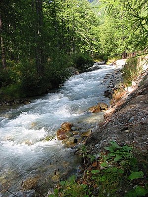
Guisane
River in France
Distance: Approx. 4035 meters
Latitude and longitude: 44.89277778,6.62972222
The Guisane is a river in the Hautes-Alpes department, Provence-Alpes-Côte d'Azur region of France, a subtributary of the Rhône and tributary of the Durance (in Briançon). It takes its source in Le Monêtier-les-Bains at the Col du Lautaret. It is 27.7 km (17.2 mi) long.
Weather in this IP's area
few clouds
22 Celsius
22 Celsius
20 Celsius
22 Celsius
1023 hPa
59 %
1023 hPa
878 hPa
10000 meters
1.4 m/s
1.94 m/s
303 degree
11 %
06:14:51
21:05:03