Country:
 Angola
Region:
City:
Latitude and Longitude:
Time Zone:
Postal Code:
IP information under different IP Channel
ip-api
Country
Region
City
ASN
Time Zone
ISP
Blacklist
Proxy
Latitude
Longitude
Postal
Route
IPinfo
Country
Region
City
ASN
Time Zone
ISP
Blacklist
Proxy
Latitude
Longitude
Postal
Route
MaxMind
Country
Region
City
ASN
Time Zone
ISP
Blacklist
Proxy
Latitude
Longitude
Postal
Route
Luminati
Country
AOASN
Time Zone
Africa/Luanda
ISP
UNITEL
Latitude
Longitude
Postal
db-ip
Country
Region
City
ASN
Time Zone
ISP
Blacklist
Proxy
Latitude
Longitude
Postal
Route
ipdata
Country
Region
City
ASN
Time Zone
ISP
Blacklist
Proxy
Latitude
Longitude
Postal
Route
Popular places and events near this IP address

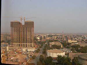
Luanda
Capital and largest city of Angola
Distance: Approx. 96 meters
Latitude and longitude: -8.83833333,13.23444444
Luanda (/luˈændə, -ˈɑːn-/, Portuguese: [luˈɐ̃dɐ]) is the capital and largest city of Angola. It is Angola's primary port, and its major industrial, cultural and urban centre. Located on Angola's northern Atlantic coast, Luanda is Angola's administrative centre, its chief seaport, and also the capital of the Luanda Province.

Quatro de Fevereiro Airport
Airport in Luanda, Angola
Distance: Approx. 2255 meters
Latitude and longitude: -8.85833333,13.23111111
Quatro de Fevereiro International Airport (Portuguese: Aeroporto Internacional 4 de Fevereiro, Swahili: Uwanja wa Ndege wa Kimataifa wa Quatro de Fevereiro), (IATA: LAD, ICAO: FNLU) is the main international airport of Angola. It is located in the southern part of the capital Luanda, situated in the Luanda Province. Quatro de Fevereiro means 4 February, which is an important national holiday in Angola, marking the start of the armed struggle against the Portuguese colonial regime on 4 February 1961.
Banco de Poupança e Crédito
Angolan commercial bank
Distance: Approx. 2276 meters
Latitude and longitude: -8.81805556,13.23527778
Banco de Poupança e Crédito (BPC) (English: Savings and Credit Bank) is a government-owned, full service bank in Angola. With some 68 branches, including one in Cabinda, it has the largest branch network in the country.

National Assembly (Angola)
Unicameral legislature of Angola
Distance: Approx. 2245 meters
Latitude and longitude: -8.81944444,13.22861111
The National Assembly (Portuguese: Assembleia Nacional) is the legislative branch of the government of Angola. Angola is a unicameral country so the National Assembly is the only legislative chamber at the national level. The People's Movement for the Liberation of Angola (MPLA) has held a majority in the Assembly since Angolan independence in 1975.

2003 Angola Boeing 727 disappearance
Stolen aircraft incident at Quatro de Fevereiro Airport
Distance: Approx. 2255 meters
Latitude and longitude: -8.85833333,13.23111111
On 25 May 2003, a Boeing 727-223 airliner, registered N844AA, was stolen at Quatro de Fevereiro Airport in Luanda, Angola, prompting a worldwide search by law enforcement intelligence agencies in the United States. No trace of the aircraft has been found.
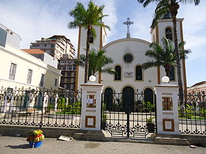
Roman Catholic Archdiocese of Luanda
Roman Catholic archdiocese in Angola
Distance: Approx. 619 meters
Latitude and longitude: -8.8333,13.2333
The Archdiocese of Luanda (Latin: Archidioecesis Luandensis) is the oldest Roman Catholic archdiocese in Angola. Its cathedral is the Church of Our Lady of Remedies (Igreja de Nossa Senhora dos Remédios) in Luanda.
National Library of Angola
Library in Luanda, Angola
Distance: Approx. 1226 meters
Latitude and longitude: -8.82830556,13.23952778
The National Library of Angola (Portuguese: Biblioteca Nacional de Angola) is located in Luanda.

Pavilhão Victorino Cunha
Distance: Approx. 1430 meters
Latitude and longitude: -8.828487,13.227153
Pavilhão Victorino Cunha, formerly Pavilhão do CODENM a.k.a. Pavilhão do Rio Seco is the Arena of Angolan side Primeiro de Agosto, mainly used for its Men's and Women's basketball teams. The arena is located in the uptown neighborhood of Maianga.
Maianga
Urban District of Luanda
Distance: Approx. 2383 meters
Latitude and longitude: -8.81805556,13.22888889
Maianga is one of the six municipalities of the administrative division of the province of Luanda, Angola. In 2011, as part of a restructuring of Luanda's regional government, the municipality was designated as one of Luanda's six urban districts. The area is one of the older quarters of Luanda and was established before independence.
Escola Portuguesa de Luanda
Portuguese international school in Luanda, Angola
Distance: Approx. 1025 meters
Latitude and longitude: -8.834068,13.243471
Escola Portuguesa de Luanda (EPL) is a Portuguese-language international school in Luanda, Angola. It serves grades one through 12.
Estádio França Ndalu
Football stadium in Luanda, Angola
Distance: Approx. 771 meters
Latitude and longitude: -8.84130283,13.24170683
Estádio França Ndalu is an Angolan football stadium built and owned by Clube Desportivo Primeiro de Agosto and will be the venue for the club's home games in all events that it takes part of. The stadium is named after Gen. António França, nicknamed "Ndalu" who was a key figure in the club's foundation in 1977.

Josina Machel Hospital
Hospital in Luanda, Angola
Distance: Approx. 1884 meters
Latitude and longitude: -8.824,13.22647
Josina Machel Hospital in Luanda is the oldest and largest state hospital in Angola. It is considered the best health facility in the country and is an important historical monument.
Weather in this IP's area
scattered clouds
25 Celsius
26 Celsius
25 Celsius
25 Celsius
1013 hPa
78 %
1013 hPa
1004 hPa
10000 meters
4.12 m/s
210 degree
40 %
05:52:16
18:02:11