Country:
 USA
USARegion:
City:
Latitude and Longitude:
Time Zone:
Postal Code:
IP information under different IP Channel
ip-api
Country
Region
City
ASN
Time Zone
ISP
Blacklist
Proxy
Latitude
Longitude
Postal
Route
IPinfo
Country
Region
City
ASN
Time Zone
ISP
Blacklist
Proxy
Latitude
Longitude
Postal
Route
MaxMind
Country
Region
City
ASN
Time Zone
ISP
Blacklist
Proxy
Latitude
Longitude
Postal
Route
Luminati
Country
USRegion
fl
City
santarosabeach
ASN
Time Zone
America/Chicago
ISP
UNITI-FIBER
Latitude
Longitude
Postal
db-ip
Country
Region
City
ASN
Time Zone
ISP
Blacklist
Proxy
Latitude
Longitude
Postal
Route
ipdata
Country
Region
City
ASN
Time Zone
ISP
Blacklist
Proxy
Latitude
Longitude
Postal
Route
Popular places and events near this IP address

Dothan, Alabama
City in and county seat of Houston County, Alabama
Distance: Approx. 1015 meters
Latitude and longitude: 31.227,-85.407
Dothan ( DOH-thən) is a city in and the county seat of Houston County in the U.S. state of Alabama. A slight portion of the city extends into Dale and Henry counties. It had a population of 71,072 at the 2020 census, making it Alabama's eighth-largest city by population and the 5th largest in Alabama by total area.

Dothan Civic Center
Distance: Approx. 1923 meters
Latitude and longitude: 31.22472222,-85.39
Dothan Civic Center is a 3,100-seat multi-purpose arena located in Dothan, Alabama. It hosts local sporting events and concerts. Ultimate Fighting Championship 12 was held at Dothan Civic Center.
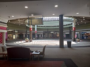
Wiregrass Commons Mall
Shopping mall in Alabama, USA
Distance: Approx. 2711 meters
Latitude and longitude: 31.25403889,-85.42443056
Wiregrass Commons Mall is an enclosed shopping mall located in Dothan, Alabama. It has 638,554 square feet (59,000 m2) of shopping with over fifty retail stores and a food court with a carousel. It is Southeast Alabama's largest and only shopping mall.

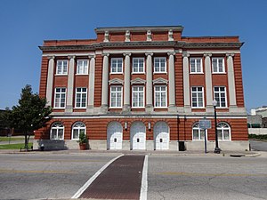
Federal Building and United States Courthouse (Dothan, Alabama)
United States historic place
Distance: Approx. 1706 meters
Latitude and longitude: 31.22527778,-85.3925
The Federal Building and U.S. Courthouse, also known as U.S. Post Office and Court House, is a historic government building in Dothan, Alabama.
Dothan Opera House
United States historic place
Distance: Approx. 1890 meters
Latitude and longitude: 31.22388889,-85.39138889
The Dothan Opera House is a historic performing arts venue in Dothan, Alabama. It was built in 1914–15 as a municipal auditorium by the growing town. Seating 800, it opened October 8, 1915, with a performance by a local orchestra.

Wiregrass Museum of Art
Distance: Approx. 2024 meters
Latitude and longitude: 31.22444444,-85.38888889
The Wiregrass Museum of Art (formerly the Dothan Municipal Light and Water Plant) is an art museum in Dothan, Alabama. The museum was founded in 1988 and is located in the city's former power and water plant. The building was listed on the Alabama Register of Landmarks and Heritage in 1990 and the National Register of Historic Places in 1991.

Dothan station
Historic train station in Dothan, Alabama
Distance: Approx. 1432 meters
Latitude and longitude: 31.23055556,-85.39166667
The Dothan station, also known as Atlantic Coastline Railroad Passenger Depot, is a historic train station in Dothan, Alabama. It was built in 1907 as the largest and busiest on the Atlantic Coast Line Railroad between Montgomery, Alabama, and Thomasville, Georgia and replaced a former freight depot. The Atlantic Coast Line merged with the Seaboard Air Line Railroad in 1967 to form the Seaboard Coast Line Railroad.
Howell School
United States historic place
Distance: Approx. 1812 meters
Latitude and longitude: 31.22861111,-85.38833333
Howell School is a historic school building in Dothan, Alabama. The school was built in 1902 to replace the previous grammar school that had burned in 1901. It was named in 1916 for the recently deceased Robert Graves Howell, who was mayor when the first grammar school was built.

Main Street Commercial District (Dothan, Alabama)
Historic district in Alabama, United States
Distance: Approx. 1899 meters
Latitude and longitude: 31.22333333,-85.39194444
The Main Street Commercial District is a historic district in Dothan, Alabama. The district covers 18 acres (7 ha) and portions of 6 blocks in Dothan's historic commercial district. At the time of the nomination, it contained 68 contributing properties, however many have been demolished in the intervening years.
George Washington Carver High School (Dothan, Alabama)
Public school in Dothan, Alabama, United States
Distance: Approx. 2376 meters
Latitude and longitude: 31.2319,-85.3808
George Washington Carver High School was a segregated public high school in Dothan, Alabama serving African-American children from 1940 to 1968. In 1969 the students were integrated with white students at Dothan High School.
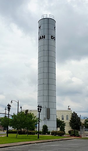
Water Works Standpipe (Dothan, Alabama)
United States historic place
Distance: Approx. 1422 meters
Latitude and longitude: 31.23027778,-85.39194444
The Water Works Standpipe in Dothan, Alabama was listed on the National Register of Historic Places in 2016. It is a water tower built in 1897, when such were called standpipes. It is located on a triangular property now known as "Dixie Park", at the intersection of East Powell and North Saint Andrews St., .5 miles (0.80 km) north of Main St.
Moody Hospital
Former hospital in Dothan, Alabama
Distance: Approx. 1243 meters
Latitude and longitude: 31.22722222,-85.39722222
Moody Hospital is a historic hospital building in Dothan, Alabama. Built in 1916, it was listed on the National Register of Historic Places in 2021.
Weather in this IP's area
overcast clouds
25 Celsius
26 Celsius
24 Celsius
25 Celsius
1018 hPa
90 %
1018 hPa
1006 hPa
10000 meters
2.18 m/s
4.05 m/s
87 degree
100 %
05:55:25
19:40:36