Country:
 USA
USARegion:
City:
Latitude and Longitude:
Time Zone:
Postal Code:
IP information under different IP Channel
ip-api
Country
Region
City
ASN
Time Zone
ISP
Blacklist
Proxy
Latitude
Longitude
Postal
Route
IPinfo
Country
Region
City
ASN
Time Zone
ISP
Blacklist
Proxy
Latitude
Longitude
Postal
Route
MaxMind
Country
Region
City
ASN
Time Zone
ISP
Blacklist
Proxy
Latitude
Longitude
Postal
Route
Luminati
Country
USASN
Time Zone
America/Chicago
ISP
UNITI-FIBER
Latitude
Longitude
Postal
db-ip
Country
Region
City
ASN
Time Zone
ISP
Blacklist
Proxy
Latitude
Longitude
Postal
Route
ipdata
Country
Region
City
ASN
Time Zone
ISP
Blacklist
Proxy
Latitude
Longitude
Postal
Route
Popular places and events near this IP address

Northport, Alabama
City in Alabama, United States
Distance: Approx. 655 meters
Latitude and longitude: 33.25388889,-87.59222222
Northport is a city in Tuscaloosa County in the west central part of the State of Alabama. Located on the Black Warrior River across from downtown Tuscaloosa, it is currently the 17th largest city in Alabama with a population of 31,125 in the 2020 US Census. It incorporated in 1871.
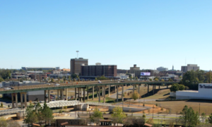
Tuscaloosa, Alabama
City in Alabama, United States
Distance: Approx. 5182 meters
Latitude and longitude: 33.20972222,-87.56916667
Tuscaloosa ( TUS-kə-LOO-sə) is a city in and the county seat of Tuscaloosa County in west-central Alabama, United States, on the Black Warrior River where the Gulf Coastal and Piedmont plains meet. Alabama's fifth-most populous city, the population was 99,600 at the 2020 census, and was estimated to be 110,602 in 2022. It was known as Tuskaloosa until the early 20th century.
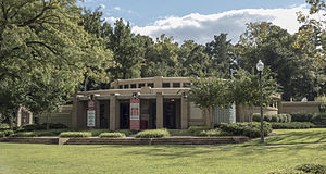
Tuscaloosa Public Library
Public library in Tuscaloosa, Alabama
Distance: Approx. 4821 meters
Latitude and longitude: 33.21561,-87.56194
The Tuscaloosa Public Library is a city/county agency in the city of Tuscaloosa, serving a population of over 184,035 in Tuscaloosa County in the state of Alabama, United States. The library has 58,037 registered patrons that use the library on a regular basis. There are currently over 225,000 items (books, DVDs, CDs, etc.) cataloged in the system.
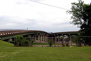
Hugh R. Thomas Bridge
Bridge in Tuscaloosa, Alabama
Distance: Approx. 4559 meters
Latitude and longitude: 33.21447,-87.57379
The Hugh Rowe Thomas Bridge is a six-lane, girder bridge spanning the Black Warrior River along U.S. Route 43 and Alabama State Route 69, connecting downtown Tuscaloosa and Northport in Tuscaloosa County, Alabama, that opened in 1974. The bridge is split in Tuscaloosa to accommodate two major, one-way thoroughfares (Lurleen Wallace Boulevard North and South), before joining heading towards Northport. It replaced a lift bridge that was built in 1922 and demolished in 1973.
Queen City Pool and Pool House
United States historic place
Distance: Approx. 4836 meters
Latitude and longitude: 33.215,-87.56305556
The Queen City Pool and Pool House, also known as the Queen City Pool, is a historic bathhouse and swimming pool located in Tuscaloosa, Alabama, United States. The bathhouse and pool were added to the National Register of Historic Places on September 9, 1992, due to their architectural and historical significance.
Tuscaloosa County High School (historical)
Distance: Approx. 2423 meters
Latitude and longitude: 33.23308333,-87.57940833
Tuscaloosa County High School original building was completed in 1926. The first graduating class was summer of 1927. The Principal was Dr.
Ol' Colony Golf Complex
Public golf course in Tuscaloosa, Alabama USA
Distance: Approx. 4392 meters
Latitude and longitude: 33.25568056,-87.53804444
Ol' Colony Golf Complex is a municipal public golf course in Tuscaloosa, Alabama. The 18-hole course opened in December 2000 on 597 acres that was once a farm plantation for a mental institution named Cain's Colony. Ol' Colony was designed by professional golfer Jerry Pate, who played golf for The University of Alabama.

Tuscaloosa Amphitheater
Outdoor amphitheater in Tuscaloosa, Alabama
Distance: Approx. 4787 meters
Latitude and longitude: 33.21219444,-87.57476944
The Tuscaloosa Amphitheater is an outdoor amphitheater in Tuscaloosa, Alabama, USA that is used primarily for music performances. It has a seating capacity of 7,470. The amphitheater is located on Jack Warner Parkway, just beside the Hugh R. Thomas Bridge, only minutes away from the University of Alabama campus and blocks from downtown Tuscaloosa.
Black Warrior Brewing Company
Craft brewery in Tuscaloosa, Alabama
Distance: Approx. 5168 meters
Latitude and longitude: 33.21064444,-87.56632778
Black Warrior Brewing Company is a craft brewery in Tuscaloosa, Alabama.
Tuscaloosa Academy
Private school
Distance: Approx. 4358 meters
Latitude and longitude: 33.2451,-87.5397
Tuscaloosa Academy (TA) is a private school in Tuscaloosa, Alabama. It has been described as a segregation academy.
Northport Historic District
Historic place in Alabama, U.S.
Distance: Approx. 3938 meters
Latitude and longitude: 33.21916667,-87.58027778
The Northport Historic District comprises the central business district of Northport, Alabama. The district comprises 20 blocks and 134 structures, dating mainly to the late 19th and early 20th centuries, particularly 1920–1925, when the town was rebuilt after a period of decline caused by an 1850 fire and the American Civil War. The earliest structures date to 1840.
Pinehurst Historic District (Tuscaloosa, Alabama)
Historic district in Alabama, United States
Distance: Approx. 5214 meters
Latitude and longitude: 33.21333333,-87.55805556
The Pinehurst Historic District in Tuscaloosa, Alabama is a residential historic district which was listed on the National Register of Historic Places in 1986. The listing included 17 contributing buildings and nine non-contributing ones. It was developed as Tuscaloosa's first garden landscaped residential area, during 1908 to 1935.
Weather in this IP's area
clear sky
24 Celsius
24 Celsius
23 Celsius
24 Celsius
1017 hPa
75 %
1017 hPa
1009 hPa
10000 meters
06:00:02
19:53:25