Country:
 USA
USARegion:
City:
Latitude and Longitude:
Time Zone:
Postal Code:
IP information under different IP Channel
ip-api
Country
Region
City
ASN
Time Zone
ISP
Blacklist
Proxy
Latitude
Longitude
Postal
Route
IPinfo
Country
Region
City
ASN
Time Zone
ISP
Blacklist
Proxy
Latitude
Longitude
Postal
Route
MaxMind
Country
Region
City
ASN
Time Zone
ISP
Blacklist
Proxy
Latitude
Longitude
Postal
Route
Luminati
Country
USRegion
ca
City
sanjose
ASN
Time Zone
America/Los_Angeles
ISP
Akamai International B.V.
Latitude
Longitude
Postal
db-ip
Country
Region
City
ASN
Time Zone
ISP
Blacklist
Proxy
Latitude
Longitude
Postal
Route
ipdata
Country
Region
City
ASN
Time Zone
ISP
Blacklist
Proxy
Latitude
Longitude
Postal
Route
Popular places and events near this IP address

San Jose, California
City in California, United States
Distance: Approx. 537 meters
Latitude and longitude: 37.33611111,-121.89055556
San Jose, officially the City of San José (Spanish for 'Saint Joseph' SAN hoh-ZAY, -SAY; Spanish: [saŋ xoˈse]), is the largest city in Northern California by both population and area. With a 2022 population of 971,233, it is the most populous city in both the Bay Area and the San Jose–San Francisco–Oakland Combined Statistical Area—which in 2022 had a population of 7.5 million and 9.0 million respectively—the third-most populous city in California after Los Angeles and San Diego, and the 13th-most populous in the United States. Located in the center of the Santa Clara Valley on the southern shore of San Francisco Bay, San Jose covers an area of 179.97 sq mi (466.1 km2).
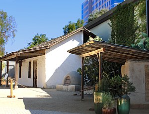
Peralta Adobe
Historic house in California, United States
Distance: Approx. 334 meters
Latitude and longitude: 37.33640278,-121.89475278
The Peralta Adobe (Spanish: Adobe Peralta), also known as the Luis María Peralta Adobe or the Gonzales-Peralta Adobe, is the oldest building in San Jose, California. The adobe was built in 1797 by José Manuel Gonzeles, one of the founders of San Jose, and is named after Luis María Peralta, its most famous resident.

Saint James station (VTA)
VTA light rail station in San Jose, California
Distance: Approx. 302 meters
Latitude and longitude: 37.3381,-121.892
Saint James station is a light rail station operated by Santa Clara Valley Transportation Authority. The station is located in Downtown San Jose, California on 1st and 2nd Streets between Saint James and Saint John Streets. The northbound platform is on 1st Street (the address is 150 N. First Street); the southbound platform is on 2nd Street (the address is 101 N. Second Street).
Arts Council Silicon Valley
Distance: Approx. 506 meters
Latitude and longitude: 37.33761,-121.88975
The Arts Council Silicon Valley (1982–2013) was the official Santa Clara County, United States arts council. Established in 1982 originally as the Cultural Council and later as Arts Council of Santa Clara County, Arts Council Silicon Valley (ACSV) was a private, nonprofit arts organization dedicated to improving the quality of life for Santa Clara County residents by creating and fostering arts and culture throughout the region. As a grant agency, the ACSV provided funding and fundraising support services to more than 140 local arts organizations and individual artists.

First Unitarian Church of San Jose
Historic church in California, United States
Distance: Approx. 453 meters
Latitude and longitude: 37.33972778,-121.88990278
The First Unitarian Church of San Jose is located at 160 North Third Street in downtown San Jose, California, across from St. James Park, and was designed in "Richardsonian Romanesque" style by architect George Page, who also designed the Hayes Mansion. Local historian Linda Larson Boston called the building, “One of a handful of American churches patterned after Unitarian churches of Transylvania, it features a large triple-arched stained glass window on the facade, multiple domes and cupolas, and both round and square towers,” in her pamphlet, Highlights of San Jose, California’s St.
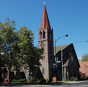
Trinity Episcopal Cathedral (San Jose, California)
Episcopal Cathedral in San Jose, California
Distance: Approx. 411 meters
Latitude and longitude: 37.337825,-121.89079722
Trinity Episcopal Cathedral is an Episcopal cathedral in San Jose, California. It is the seat of the Episcopal Diocese of El Camino Real.

San Jose electric light tower
Distance: Approx. 507 meters
Latitude and longitude: 37.335488,-121.892074
The San Jose electric light tower, also known as Owen's Electric Tower after its creator and chief booster, was constructed in 1881 at an intersection in downtown San Jose, California, as a "high light" or moonlight tower to light the city using arc lights. A pioneer use of electricity for municipal lighting, it was later strung with incandescent bulbs and was destroyed in a storm in December 1915. A half-size replica stands at History Park at Kelley Park.
Washburn Preparatory School
Preparatory school in California, United States
Distance: Approx. 115 meters
Latitude and longitude: 37.33861111,-121.89583333
Washburn Preparatory School or Washburn College Preparatory School (1894–1911) was a private preparatory school that was located at 165 Devine Street at the corner of San Pedro Street in San Jose, California.
CreaTV San Jose
Distance: Approx. 233 meters
Latitude and longitude: 37.33777778,-121.89666667
CreaTV San Jose (abbreviated CRTV) is a nonprofit organization based in San Jose, California, United States, that broadcasts several public-access television channels in San Jose and the surrounding Silicon Valley area. Under federal law, CreaTV receives a share of the gross revenue of local cable franchisees Comcast and AT&T, which amounted to $1.2 million in 2009.

St. James Park (San Jose)
Park in San Jose, California
Distance: Approx. 340 meters
Latitude and longitude: 37.338949,-121.891203
St. James Park is a 6.8-acre (2.8 ha) park in downtown San Jose, California. Originally laid out as St.
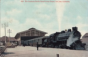
Market Street Depot
Distance: Approx. 199 meters
Latitude and longitude: 37.341,-121.896
Market Street Depot was the primary intercity railway station in San Jose, California between 1883 and 1935. It was located at Market and Bassett Streets at the end of the former San Francisco and San Jose Railroad, a route which was later integrated into the Southern Pacific Railroad Coast Line.
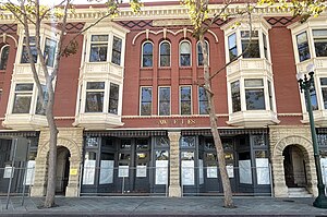
Moir Building
Historic building in California, United States
Distance: Approx. 152 meters
Latitude and longitude: 37.33972222,-121.89333333
The Moir Building, was formerly the Straford Hotel, and then in the 1930s named the St. James Hotel. It is a historic building located in downtown San Jose, California, next to the St.
Weather in this IP's area
clear sky
26 Celsius
26 Celsius
21 Celsius
29 Celsius
1012 hPa
46 %
1012 hPa
1009 hPa
10000 meters
5.66 m/s
340 degree
06:09:09
20:18:45