Country:
 New Zealand
Region:
City:
Latitude and Longitude:
Time Zone:
Postal Code:
IP information under different IP Channel
ip-api
Country
Region
City
ASN
Time Zone
ISP
Blacklist
Proxy
Latitude
Longitude
Postal
Route
IPinfo
Country
Region
City
ASN
Time Zone
ISP
Blacklist
Proxy
Latitude
Longitude
Postal
Route
MaxMind
Country
Region
City
ASN
Time Zone
ISP
Blacklist
Proxy
Latitude
Longitude
Postal
Route
Luminati
Country
NZASN
Time Zone
Pacific/Auckland
ISP
Hoopla Hosting Limited
Latitude
Longitude
Postal
db-ip
Country
Region
City
ASN
Time Zone
ISP
Blacklist
Proxy
Latitude
Longitude
Postal
Route
ipdata
Country
Region
City
ASN
Time Zone
ISP
Blacklist
Proxy
Latitude
Longitude
Postal
Route
Popular places and events near this IP address
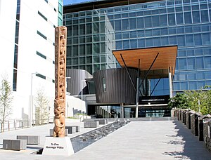
Christchurch City Council
Local government authority for Christchurch, New Zealand
Distance: Approx. 197 meters
Latitude and longitude: -43.53174,172.63173
The Christchurch City Council is the local government authority for Christchurch in New Zealand. It is a territorial authority elected to represent the 396,200 people of Christchurch. Since October 2022, the Mayor of Christchurch is Phil Mauger, who succeeded after the retirement of Lianne Dalziel.
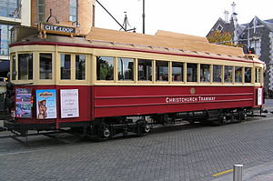
Christchurch tramway system
Tram transport network of Christchurch, New Zealand
Distance: Approx. 260 meters
Latitude and longitude: -43.53091667,172.63444444
The Christchurch tramway system was an extensive network in Christchurch, New Zealand, with steam and horse trams from 1882. Electric trams ran from 1905 to 1954, when the last line from Cashmere to Papanui was replaced by buses. In 1995, a 2.5-kilometre (1.6 mi) central city loop heritage tram was reopened in the central city as a tourist attraction.

Ballantyne's fire
1947 fire in Christchurch, New Zealand
Distance: Approx. 238 meters
Latitude and longitude: -43.533414,172.63622
On Tuesday, 18 November 1947, a fire engulfed the Ballantynes department store in central Christchurch, New Zealand, resulting in the death of 41 people. It remains the deadliest fire in New Zealand's history.

St Michael's Church School
School
Distance: Approx. 186 meters
Latitude and longitude: -43.53477,172.63322
St Michael's is a co-educational Anglican private primary and intermediate day school situated in the city centre of Christchurch, New Zealand. The school provides an education for year zero to year eight. It is associated with the Church of St Michael and All Angels.

Statue of Robert Falcon Scott, Christchurch
Statue in Christchurch
Distance: Approx. 213 meters
Latitude and longitude: -43.5312,172.63361
The Statue of Robert Falcon Scott commemorates Antarctic explorer Robert Falcon Scott. It is located at the intersection of Oxford Terrace and Worcester Street in the Christchurch Central City, New Zealand. The statue, carved by Scott's widow Kathleen Scott, is registered as a Category II historic place.
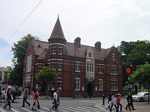
Our City, Christchurch
Former civic offices in Christchurch, New Zealand
Distance: Approx. 257 meters
Latitude and longitude: -43.5308,172.6336
Our City, more formally Our City O-Tautahi, also known as the Old Municipal Chambers, is a Queen Anne style building on the corner of Worcester Street and Oxford Terrace in the Christchurch Central City. It is a Category I heritage building registered with Heritage New Zealand. From 1887 to 1924 it was used by Christchurch City Council as their civic offices, providing room for meetings of the council and for housing staff, before they moved to the Civic.

Bridge of Remembrance
War memorial in Christchurch, New Zealand
Distance: Approx. 8 meters
Latitude and longitude: -43.5331,172.6334
The Bridge of Remembrance is one of two main war memorials in Christchurch, New Zealand. It is dedicated to those who died in World War I, and serves as a memorial for those who participated in two World Wars as well as subsequent conflicts in Borneo, Korea, Malaya, and Vietnam. Owned by Christchurch City Council, it is located on the Cashel Street Bridge at the head of City Mall.
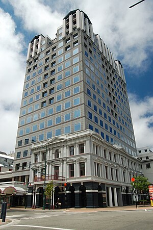
Clarendon Tower
Former building in Christchurch, NZ
Distance: Approx. 203 meters
Latitude and longitude: -43.53138889,172.63416667
Clarendon Tower was a high rise building on Worcester Street at Oxford Terrace in the Christchurch Central City, New Zealand. Built on the site of the former Clarendon Hotel, the façade of the historic building was kept in the redevelopment and was protected by the New Zealand Historic Places Trust as a Category II heritage structure. Following damage from the February 2011 Christchurch earthquake, the 17-storey building has been demolished.
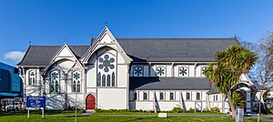
Church of St Michael and All Angels, Christchurch
Church in Christchurch Central City, New Zealand
Distance: Approx. 151 meters
Latitude and longitude: -43.53444444,172.63305556
The Church of St Michael and All Angels is an Anglican church located at 84 Oxford Terrace, Christchurch, New Zealand. The church building is registered as Category I by Heritage New Zealand. Its freestanding belfry is registered separately.
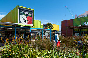
Re:START
Temporary mall in Christchurch, New Zealand
Distance: Approx. 144 meters
Latitude and longitude: -43.53326944,172.635075
Container Mall (originally called Re:START) was a temporary mall built from shipping containers in Christchurch Central City, New Zealand. It was a response to the 22 February 2011 Christchurch earthquake, which destroyed most buildings in City Mall (Cashel and High Streets), and resulted in the central city being cordoned off from public access while buildings were being demolished. Initially considered a short-term response to the lack of permanent buildings, Re:START was popular with locals and tourists alike and remained open for business until January 2018.

Canterbury Club
Gentlemen's Club in Christchurch, New Zealand
Distance: Approx. 227 meters
Latitude and longitude: -43.53111667,172.63262222
The Canterbury Club is a historic gentlemen's club in the central city of Christchurch, New Zealand. It was founded by urban professionals in 1872 as a breakaway club from the Christchurch Club, which had been set up by large rural landholders in 1856.
Canterbury Earthquake National Memorial
Official memorial for the victims of the Christchurch earthquake
Distance: Approx. 218 meters
Latitude and longitude: -43.53455,172.63149
The Canterbury Earthquake National Memorial (Māori: Oi Manawa) is the Crown's official memorial for those killed or seriously injured in the 22 February 2011 Christchurch earthquake. It is located on both sides of the Avon River downstream from the Montreal Street bridge. The memorial opened on 22 February 2017, the sixth anniversary of the earthquake.
Weather in this IP's area
overcast clouds
5 Celsius
4 Celsius
4 Celsius
7 Celsius
1015 hPa
80 %
1015 hPa
1013 hPa
10000 meters
1.44 m/s
1.93 m/s
302 degree
100 %
07:47:05
17:24:36