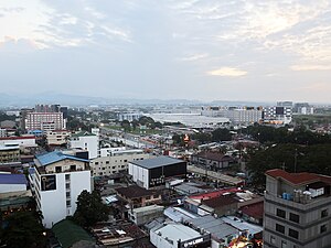
Country:
 The Philippines
Region:
City:
Latitude and Longitude:
Time Zone:
Postal Code:
IP information under different IP Channel
ip-api
Country
Region
City
ASN
Time Zone
ISP
Blacklist
Proxy
Latitude
Longitude
Postal
Route
IPinfo
Country
Region
City
ASN
Time Zone
ISP
Blacklist
Proxy
Latitude
Longitude
Postal
Route
MaxMind
Country
Region
City
ASN
Time Zone
ISP
Blacklist
Proxy
Latitude
Longitude
Postal
Route
Luminati
Country
PHASN
Time Zone
Asia/Manila
ISP
Converge ICT Solutions Inc.
Latitude
Longitude
Postal
db-ip
Country
Region
City
ASN
Time Zone
ISP
Blacklist
Proxy
Latitude
Longitude
Postal
Route
ipdata
Country
Region
City
ASN
Time Zone
ISP
Blacklist
Proxy
Latitude
Longitude
Postal
Route
Popular places and events near this IP address

Clark Air Base
Philippine Air Force base on Luzon Island
Distance: Approx. 4251 meters
Latitude and longitude: 15.18583333,120.55972222
Clark Air Base is a Philippine Air Force base on Luzon Island in the Philippines, located 3 miles (4.8 km) west of Angeles City, and about 40 miles (64 km) northwest of Metro Manila. Clark Air Base was previously a United States military facility, operated by the U.S. Air Force under the aegis of Pacific Air Forces (PACAF) and their predecessor organizations from 1903 to 1991. The base covered 14.3 square miles (37 km2) with a military reservation extending north that covered another 230 square miles (600 km2).
Mabalacat
Component city in Pampanga, Philippines
Distance: Approx. 710 meters
Latitude and longitude: 15.22,120.58
Mabalacat, officially Mabalacat City (Kapampangan: Lakanbalen/Ciudad ning Mabalacat; Filipino: Lungsod ng Mabalacat), is a 3rd class component city in the province of Pampanga, Philippines. According to the 2020 census, it has a population of 293,244 people. Mabalacat is in the urban core of Metro Clark, also known as Metro Angeles, an urban area in Pampanga.

Clark International Airport
Commercial airport near Mabalacat, Pampanga, Philippines
Distance: Approx. 4251 meters
Latitude and longitude: 15.18583333,120.55972222
Clark International Airport (IATA: CRK, ICAO: RPLC), known as Diosdado Macapagal International Airport from 2003 to 2014, is an international airport covering portions of the cities of Angeles and Mabalacat within the Clark Freeport and Special Economic Zone in the province of Pampanga, Philippines. It is located 80 kilometers (50 mi) northwest of Manila. It is accessible by way of the Subic–Clark–Tarlac Expressway (SCTEX).
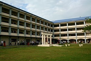
Don Bosco Academy, Pampanga
Roman Catholic school in Pampanga, Philippines
Distance: Approx. 1555 meters
Latitude and longitude: 15.21387,120.58566
Don Bosco Academy also referred to by its acronym DBA or Don Bosco Pampanga" is a private Catholic Salesian technical educational institution for boys run by the Salesians of the Society of Saint John Bosco in Mabalacat, Pampanga, Philippines. It was founded in 1956 by the (Salesians). The school was named after St.

Clark International Speedway
Motorsport race track in Philippines
Distance: Approx. 4172 meters
Latitude and longitude: 15.20777778,120.5375
Clark International Speedway, abbreviated as CIS, is a motorsport venue at the Clark Freeport Zone in Mabalacat, Pampanga, Philippines.

Mabalacat College
Public college in Pampanga, Philippines
Distance: Approx. 2317 meters
Latitude and longitude: 15.24158,120.56754
Mabalacat City College (MCC) is an institution of higher learning funded and managed by the Mabalacat City government, Pampanga, Philippines.
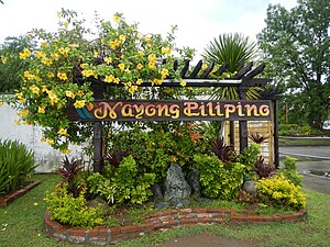
Nayong Pilipino Clark
Distance: Approx. 5121 meters
Latitude and longitude: 15.203,120.53
The Nayong Pilipino Clark is a cultural park featuring themed areas of Filipino culture at the Clark Freeport Zone in Mabalacat, Pampanga.
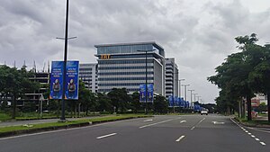
Clark Global City
Central Business District in Central Luzon, Philippines
Distance: Approx. 4819 meters
Latitude and longitude: 15.17838889,120.57625
Clark Global City (formerly the Global Gateway Logistics City) is a planned mixed-use central business district development at the Clark Freeport Zone in Mabalacat and Angeles City, Philippines. Udenna Corporation is responsible for the development of Clark Global City since 2017. The development was initially meant as a product of Kuwaiti investment and was known as the Global Gateway Logistics City.

Bamban Bridge
Bridge in Tarlac and Mabalacat, Pampanga
Distance: Approx. 4569 meters
Latitude and longitude: 15.26041944,120.55978056
Banban Bridge is a highway bridge in Central Luzon, Philippines which is part of the MacArthur Highway (N2). The bridge was constructed from 1996 to 1998 as part of the rehabilitation efforts on National Highway 3 following the 1991 eruption of Mount Pinatubo. It is one of the longest basket handle Nielsen-Lohse bridges in the world spanning a 174 meters (571 ft) long and is one of the first of its kind in the Philippines.

The Medical City Clark
Private hospital in Pampanga, Philippines
Distance: Approx. 4830 meters
Latitude and longitude: 15.17825,120.57175
The Medical City Clark is a tertiary care hospital at the Clark Global City in Mabalacat, Pampanga, Philippines. It is a hospital under The Medical City (TMC) which maintains a network of hospitals and clinics which are mostly based in the Philippines.
Clark International Airport station
A future station of the North South Commuter Railway.
Distance: Approx. 3128 meters
Latitude and longitude: 15.19881,120.55656
Clark International Airport station is an under-construction underground North–South Commuter Railway (NSCR) airport rail link station located in Pampanga, Philippines. The station will host the first direct airport rail link in the country, being connected to its namesake, the Clark International Airport.

Sacobia Bridge
Bridge in Mabalacat City, Pampanga
Distance: Approx. 4371 meters
Latitude and longitude: 15.2155,120.5334
The Sacobia Bridge is a road bridge in Mabalacat City, Pampanga. The structure crosses over the Sacobia River. It is part of the New Clark City (NCC)-Clark International Airport access road which connects New Clark City with the Clark Freeport Zone.
Weather in this IP's area
light rain
30 Celsius
35 Celsius
30 Celsius
30 Celsius
1008 hPa
70 %
1008 hPa
996 hPa
7880 meters
1.1 m/s
2.37 m/s
203 degree
95 %
05:39:15
18:28:53