Country:
 Australia
Region:
City:
Latitude and Longitude:
Time Zone:
Postal Code:
IP information under different IP Channel
ip-api
Country
Region
City
ASN
Time Zone
ISP
Blacklist
Proxy
Latitude
Longitude
Postal
Route
IPinfo
Country
Region
City
ASN
Time Zone
ISP
Blacklist
Proxy
Latitude
Longitude
Postal
Route
MaxMind
Country
Region
City
ASN
Time Zone
ISP
Blacklist
Proxy
Latitude
Longitude
Postal
Route
Luminati
Country
AUASN
Time Zone
Australia/Sydney
ISP
AMAZON-02
Latitude
Longitude
Postal
db-ip
Country
Region
City
ASN
Time Zone
ISP
Blacklist
Proxy
Latitude
Longitude
Postal
Route
ipdata
Country
Region
City
ASN
Time Zone
ISP
Blacklist
Proxy
Latitude
Longitude
Postal
Route
Popular places and events near this IP address

City of Melbourne
Local government area in Victoria, Australia
Distance: Approx. 45 meters
Latitude and longitude: -37.81361111,144.96305556
The City of Melbourne is a local government area in Victoria, Australia, located in the central city area of Melbourne. In 2021, the city has an area of 37.7 square kilometres (14.6 sq mi) and had a population of 149,615. The city's motto is "vires acquirit eundo" which means "we gather strength as we go".

Timeline of Melbourne history
Distance: Approx. 22 meters
Latitude and longitude: -37.814167,144.963056
The following is a timeline of the history of the city of Melbourne, Victoria, Australia.
Hoddle Grid
Layout of the Melbourne central business district
Distance: Approx. 22 meters
Latitude and longitude: -37.81416667,144.96305556
The Hoddle Grid is the contemporary name given to the approximately 1-by-0.5-mile (1.61 km × 0.80 km) grid of streets that form the Melbourne central business district, Australia. Bounded by Flinders Street, Spring Street, La Trobe Street, and Spencer Street, it lies at an angle to the rest of the Melbourne suburban grid, and so is easily recognisable. It is named after the surveyor Robert Hoddle, who marked it out in 1837 (to Lonsdale Street, extended to La Trobe Street the next year), establishing the first formal town plan.
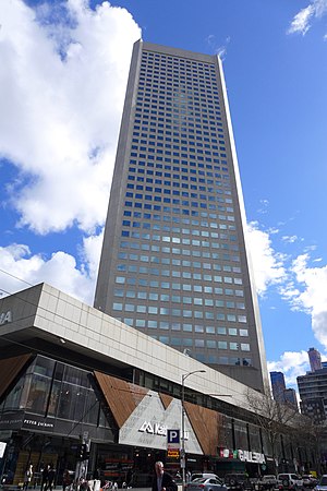
385 Bourke Street
High-rise office building located in Melbourne, Australia
Distance: Approx. 91 meters
Latitude and longitude: -37.814776,144.962888
385 Bourke Street (also known as the State Bank Centre) is a high-rise office building located in Melbourne, Australia. It is the former head office of the State Bank of Victoria and Commonwealth Bank of Australia. It is located at 385 Bourke Street on the corner of Bourke and Elizabeth Streets.

Parks and gardens of Melbourne
Parks and gardens in Melbourne, VIC, Australia
Distance: Approx. 94 meters
Latitude and longitude: -37.81316944,144.96298056
Melbourne is Australia's second largest city and widely considered to be a garden city, with Victoria being nicknamed "the Garden State". Renowned as one of the most livable cities in the world, there is an abundance of parks, gardens and green belts close to the CBD with a variety of common and rare plant species amid landscaped vistas, pedestrian pathways, and tree-lined avenues, all managed by Parks Victoria. The first superintendent of the Port Phillip region, Charles La Trobe, set aside large tracts of land around the city for open space, parkland and gardens.
Distorted Music Festival
Australian electronic music festival
Distance: Approx. 45 meters
Latitude and longitude: -37.81361111,144.96305556
The Distorted Music Festival was an Australian electronic music festival held at Melbourne's Brown Alley on 10 December 2005. It showcased electronic artists who are not generally considered to be mainstream. It covered the musical genres of industrial, noise, power noise, breakcore, IDM and glitch.
Festival Melbourne2006
Distance: Approx. 45 meters
Latitude and longitude: -37.81361111,144.96305556
Festival Melbourne2006 was a twelve-day cultural event which ran concurrently with the 2006 Commonwealth Games in the Australian city of Melbourne.

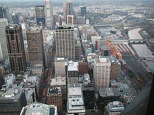
Melbourne central business district
Central business district of Melbourne, Victoria, Australia
Distance: Approx. 18 meters
Latitude and longitude: -37.814,144.963
The Melbourne central business district (also known colloquially as simply "the City" or "the CBD") is the city centre and main urban area of the city of Melbourne, Victoria, Australia, centred on the Hoddle Grid, the oldest part of the city laid out in 1837, and includes its fringes. The Melbourne CBD is located mostly in the local government area of the City of Melbourne, which also includes some of inner suburbs adjoining the CBD, while a small section extends into the City of Port Phillip. The contemporary locality of Melbourne includes within its boundaries the Hoddle Grid plus the area of parallel streets just to the north up to Victoria Street including the Queen Victoria Market, but not the Flagstaff Gardens, and the area between Flinders Street and the Yarra River.
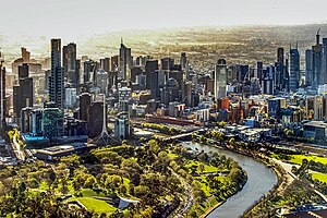
Melbourne
Capital city of Victoria, Australia
Distance: Approx. 22 meters
Latitude and longitude: -37.81416667,144.96305556
Melbourne ( MEL-bərn, locally [ˈmæɫbən] ; Boonwurrung/Woiwurrung: Narrm or Naarm) is the capital and most populous city of the Australian state of Victoria, and the second-most populous city in Australia, after Sydney. Its name generally refers to a 9,993 km2 (3,858 sq mi) metropolitan area also known as Greater Melbourne, comprising an urban agglomeration of 31 local municipalities, although the name is also used specifically for the local municipality of City of Melbourne based around its central business area. The metropolis occupies much of the northern and eastern coastlines of Port Phillip Bay and spreads into the Mornington Peninsula, part of West Gippsland, as well as the hinterlands towards the Yarra Valley, the Dandenong Ranges, and the Macedon Ranges.

General Post Office, Melbourne
Historic post office building in Melbourne, Victoria
Distance: Approx. 23 meters
Latitude and longitude: -37.81384,144.963028
The General Post Office, situated on the corner of Elizabeth and Bourke streets in Melbourne, is the former General Post Office for Victoria, Australia. Still owned by the Federal Government, the building appears on all major heritage lists: the National Trust of Victoria (Australia), the Commonwealth Heritage List, and the state of Victoria where it is noted for its fine and impressive architecture and historical significance. The location of the post office is still used as a point of reference for the measure of distances from the centre of Melbourne.

Deva House
Distance: Approx. 86 meters
Latitude and longitude: -37.8142,144.96414
Deva House is a 1926 commercial building in Melbourne, Australia designed by Harry Norris, one of the most prolific architects in the city during the period from 1920 to 1930, and noted for his Art Deco buildings, incorporating both emerging Australian and American architectural styles.

Electoral district of City of Melbourne
Former electoral district of the Victorian Legislative Council
Distance: Approx. 45 meters
Latitude and longitude: -37.81361111,144.96305556
The Electoral district of City of Melbourne was one of the original sixteen electoral districts of the old unicameral Victorian Legislative Council of 1851 to 1856; Victoria having been made a separate colony in Australia in the former year. The Electoral district of City of Melbourne's area contained the North Melbourne and part of Jika Jika parishes, and was bound in part by Merri Creek, Moonee Ponds and Hobson's Bay. William Westgarth had been a representative in the New South Wales Legislative Council for the City of Melbourne, and topped the poll for this new district in Victoria.
Weather in this IP's area
light intensity drizzle
7 Celsius
6 Celsius
6 Celsius
8 Celsius
1029 hPa
90 %
1029 hPa
1025 hPa
10000 meters
2.57 m/s
260 degree
75 %
07:22:59
17:30:02