Country:
 The Philippines
Region:
City:
Latitude and Longitude:
Time Zone:
Postal Code:
IP information under different IP Channel
ip-api
Country
Region
City
ASN
Time Zone
ISP
Blacklist
Proxy
Latitude
Longitude
Postal
Route
IPinfo
Country
Region
City
ASN
Time Zone
ISP
Blacklist
Proxy
Latitude
Longitude
Postal
Route
MaxMind
Country
Region
City
ASN
Time Zone
ISP
Blacklist
Proxy
Latitude
Longitude
Postal
Route
Luminati
Country
PHRegion
40
City
santarosa
ASN
Time Zone
Asia/Manila
ISP
RoyalCable Flash
Latitude
Longitude
Postal
db-ip
Country
Region
City
ASN
Time Zone
ISP
Blacklist
Proxy
Latitude
Longitude
Postal
Route
ipdata
Country
Region
City
ASN
Time Zone
ISP
Blacklist
Proxy
Latitude
Longitude
Postal
Route
Popular places and events near this IP address

Calamba, Laguna
Component city in Laguna, Philippines
Distance: Approx. 1059 meters
Latitude and longitude: 14.22,121.17
Calamba, officially the City of Calamba (Filipino: Lungsod ng Calamba), is a 1st class component city in the province of Laguna, Philippines. According to the 2020 census, it has a population of 539,671 people making it the largest city in the province. Calamba is the regional center of the Calabarzon region.

San Juan River (Calamba)
River in Calabarzon, Philippines
Distance: Approx. 590 meters
Latitude and longitude: 14.2167,121.167
The San Juan River (Tagalog: Ilog ng San Juan), also known as the Calamba River, is a river system in Calamba, Laguna, Philippines. It is one of 21 major tributaries of Laguna de Bay and is regularly monitored by the Laguna Lake Development Authority (LLDA) through one of its 15 river monitoring stations. Along with the San Cristobal River, it is one of the two major rivers of Calamba that drains into Laguna de Bay.
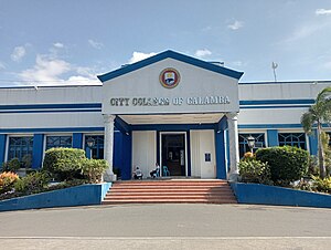
City College of Calamba
Public college in Laguna, Philippines
Distance: Approx. 255 meters
Latitude and longitude: 14.21222222,121.1675
City College of Calamba (CCC) is a public college in Calamba, Laguna established in 2006. The institution was founded to provide education to the underprivileged. It is also subsidized by the city government and offers free tuition.
Laguna College of Business and Arts
Private college in Laguna, Philippines
Distance: Approx. 358 meters
Latitude and longitude: 14.210507,121.162116
Laguna College of Business and Arts (LCBA), formerly known as the Laguna Institute, is a private non-sectarian school in Calamba, Laguna, Philippines. The campus was established in June 1930, as the first secondary school in Calamba.

Calamba station
Distance: Approx. 933 meters
Latitude and longitude: 14.20695,121.15807778
Calamba station is a railway station located on the South Main Line in Laguna, Philippines. It is one of two railway stations in the city and it is a major station on the line, serving as the junction between the South Main Line and the old Calamba–Batangas branch line which used to connect to Batangas City. It is also envisioned to be the terminus of the Commuter Express when rehabilitation work is complete.
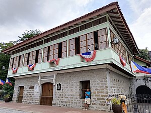
Rizal Shrine (Calamba)
Historic mansion in Laguna, Philippines
Distance: Approx. 282 meters
Latitude and longitude: 14.213677,121.166827
The Rizal Shrine in Calamba (Filipino: Museo ni José Rizal Calamba) is a reproduction of the original two-story, Spanish-colonial style house in Calamba, Laguna where José Rizal was born on June 19, 1861. Rizal is regarded as one of the greatest national heroes of the Philippines. The house is designated as a National Shrine (Level 1) by the National Historical Commission of the Philippines.

Saint John the Baptist Parish Church (Calamba)
Roman Catholic church in Laguna, Philippines
Distance: Approx. 320 meters
Latitude and longitude: 14.213477,121.167528
St. John the Baptist Parish Church (Filipino: Simbahan ng Parokya ni San Juan Bautista), commonly known as Calamba Church, is the oldest Roman Catholic church in Calamba, Laguna, Philippines under the Roman Catholic Diocese of San Pablo. It is located adjacent to Rizal Shrine and is known as the christening site of José Rizal.

Calamba Claypot
Distance: Approx. 345 meters
Latitude and longitude: 14.214215,121.16707
Calamba Claypot, also known as the Calamba Jar and The Banga, is a landmark in Calamba, Laguna, Philippines which is the largest claypot in the world. It is located at the City Plaza near Calamba Church and Rizal Shrine. Built in 1937, it was constructed as a reference to the origin of the town's name from kalamba, meaning "water jar", with names of the cities and villages inscribed on its exterior.
Rizal Monument (Calamba)
Monument in Laguna, Philippines
Distance: Approx. 1867 meters
Latitude and longitude: 14.1958,121.1597
The Rizal Monument in Calamba is a monument built to commemorate the sesquicentennial (150th) birth anniversary of Dr. José Rizal, the Philippines' unofficial national hero and the greatest son of Calamba. It is a 6.7 metres (22 ft) statue sculpted by Jonas Roces and is located at The Plaza, a 6.7-hectare (17-acre) park in front of the Calamba City Hall Complex along Bacnotan Road in the barangay of Real.
Pansol
Barangay in Calamba, Philippines
Distance: Approx. 1968 meters
Latitude and longitude: 14.19527778,121.17194444
Pansol is an urban barangay in Calamba, Laguna, Philippines. It is located at the southeast edge of the city. The barangay is situated at the foot of Mount Makiling near the city's border with Los Baños and is known for its hot springs.

Calamba Medical Center
Private hospital in Laguna, Philippines
Distance: Approx. 1593 meters
Latitude and longitude: 14.206,121.15166
Calamba Medical Center (CMC) is a private hospital in Calamba, located in the province of Laguna, Philippines. The medical center started as a 25-bed hospital in 1989.

Calamba City Hall
Government building in Laguna, Philippines
Distance: Approx. 2065 meters
Latitude and longitude: 14.19386,121.15996
The Calamba City Hall (Filipino: Gusaling Panlungsod ng Calamba), officially the City Hall of Calamba is located in the plaza of Calamba, Laguna in the Philippines. It is where the mayor of the city holds office and the chambers in the Calamba City Council., The old Calamba City Hall was located near the St. John the Baptist Parish Church and the Calamba Claypot which is the current site of City College of Calamba.
Weather in this IP's area
heavy intensity rain
24 Celsius
25 Celsius
24 Celsius
26 Celsius
1010 hPa
90 %
1010 hPa
1008 hPa
10000 meters
1.61 m/s
2.94 m/s
272 degree
100 %
05:38:22
18:25:02