Country:
 Angola
Region:
City:
Latitude and Longitude:
Time Zone:
Postal Code:
IP information under different IP Channel
ip-api
Country
Region
City
ASN
Time Zone
ISP
Blacklist
Proxy
Latitude
Longitude
Postal
Route
IPinfo
Country
Region
City
ASN
Time Zone
ISP
Blacklist
Proxy
Latitude
Longitude
Postal
Route
MaxMind
Country
Region
City
ASN
Time Zone
ISP
Blacklist
Proxy
Latitude
Longitude
Postal
Route
Luminati
Country
AOASN
Time Zone
Africa/Luanda
ISP
Sociedade-Mineira-de-Catoca-Lda
Latitude
Longitude
Postal
db-ip
Country
Region
City
ASN
Time Zone
ISP
Blacklist
Proxy
Latitude
Longitude
Postal
Route
ipdata
Country
Region
City
ASN
Time Zone
ISP
Blacklist
Proxy
Latitude
Longitude
Postal
Route
Popular places and events near this IP address
Banco de Poupança e Crédito
Angolan commercial bank
Distance: Approx. 674 meters
Latitude and longitude: -8.81805556,13.23527778
Banco de Poupança e Crédito (BPC) (English: Savings and Credit Bank) is a government-owned, full service bank in Angola. With some 68 branches, including one in Cabinda, it has the largest branch network in the country.

National Assembly (Angola)
Unicameral legislature of Angola
Distance: Approx. 561 meters
Latitude and longitude: -8.81944444,13.22861111
The National Assembly (Portuguese: Assembleia Nacional) is the legislative branch of the government of Angola. Angola is a unicameral country so the National Assembly is the only legislative chamber at the national level. The People's Movement for the Liberation of Angola (MPLA) has held a majority in the Assembly since Angolan independence in 1975.
Estádio dos Coqueiros
Sports venue in Luanda, Angola
Distance: Approx. 462 meters
Latitude and longitude: -8.814293,13.226014
Estádio dos Coqueiros is a multi-use stadium in Luanda, Angola. It is currently used mostly for football matches and is the home ground of Benfica de Luanda and Kabuscorp. The stadium holds 12,000 people and was built during the colonial period, in 1947.

National Bank of Angola
Central bank of Angola
Distance: Approx. 610 meters
Latitude and longitude: -8.81073,13.23407
The National Bank of Angola (Portuguese: Banco Nacional de Angola) is the central bank of Angola. It is state-owned and the Government of Angola is the sole shareholder. The bank is based in Luanda, and was created in 1926, but traces its ancestry back to 1865.

Fortress of São Miguel
17th-century Portuguese fortress in Angola
Distance: Approx. 1030 meters
Latitude and longitude: -8.8083,13.2234
Fortaleza de São Miguel or Saint Michael Fortress was a Portuguese fortress built in 1576 in the Ingombota District of Luanda, Angola. During Dutch rule in Angola between 1641 and 1648, the fort was known as Fort Aardenburgh.
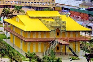
Palácio de Ferro
Distance: Approx. 658 meters
Latitude and longitude: -8.812011,13.235551
Palácio de Ferro (English: Iron Palace) is a historical building in the Angolan capital Luanda, believed to have been designed and built by – or by someone associated with – Gustave Eiffel, builder of the world-famous icons, the Eiffel Tower in Paris and the Statue of Liberty in New York City. The history of the structure is shrouded in mystery since no official record of it exists. It is believed to have been pre-built in the 1890s in France and was destined to be placed in Madagascar via boat.
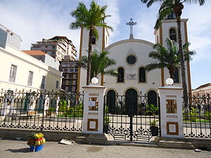
Church of Our Lady of Remedies
Church in Luanda, Angola
Distance: Approx. 128 meters
Latitude and longitude: -8.81361111,13.22972222
The Church of Our Lady of Remedies (Portuguese: Igreja de Nossa Senhora dos Remédios) is a Roman Catholic cathedral in Luanda, Angola. It was built in 1628 and is the seat of the Roman Catholic Archbishop of Luanda. In 1716 the headquarters of the Diocese of Angola and Congo was transferred from São Salvador of Congo to Luanda, which eventually led the church of Dos Remedios to become cathedral.
Ingombota
Urban District of Luanda
Distance: Approx. 405 meters
Latitude and longitude: -8.81805556,13.22888889
Ingombota is one of the six urban districts that make up the municipality of Luanda, in the province of Luanda, the capital city of Angola. Ingombota is home to the central business district of Luanda, Angola. The economic, political and symbolic center of the city and the nation, it is Luanda's oldest district.
Maianga
Urban District of Luanda
Distance: Approx. 405 meters
Latitude and longitude: -8.81805556,13.22888889
Maianga is one of the six municipalities of the administrative division of the province of Luanda, Angola. In 2011, as part of a restructuring of Luanda's regional government, the municipality was designated as one of Luanda's six urban districts. The area is one of the older quarters of Luanda and was established before independence.

Nossa Senhora do Carmo
Church in Luanda, Angola
Distance: Approx. 353 meters
Latitude and longitude: -8.81611111,13.23305556
Igreja e Convento de Nossa Senhora do Carmo (Church and Convent of Our Lady of Mount Carmel), also Igreja do Carmo or Carmo's Church, is a church and convent complex in Luanda, Angola. Thanks to its good condition, the church is considered to be one of the country's most important religious monuments. Under the patronage of Queen Luisa de Guzmán, the church was completed in 1689.

Museu Nacional de Antropologia (Angola)
National Museum of Anthropology (Angola)
Distance: Approx. 287 meters
Latitude and longitude: -8.813547,13.227844
The Museu Nacional de Antropologia (National Museum of Anthropology) is an anthropological museum in the Ingombota District of the city of Luanda, Angola. Founded on 13 November 1976, it is a cultural and scientific institution, dedicated to the collection, research, conservation, presentation and dissemination of the Angolan cultural heritage.

Josina Machel Hospital
Hospital in Luanda, Angola
Distance: Approx. 1118 meters
Latitude and longitude: -8.824,13.22647
Josina Machel Hospital in Luanda is the oldest and largest state hospital in Angola. It is considered the best health facility in the country and is an important historical monument.
Weather in this IP's area
scattered clouds
24 Celsius
25 Celsius
24 Celsius
24 Celsius
1014 hPa
78 %
1014 hPa
1011 hPa
10000 meters
3.6 m/s
200 degree
40 %
05:52:17
18:02:12